Earthquake KERMADEC ISLANDS REGION
Thu, 24 Feb 2022 21:00:45 GMT
Time3 years ago
Location
-31.2900, 179.8400
Depth
395.0 KM
Event Summary
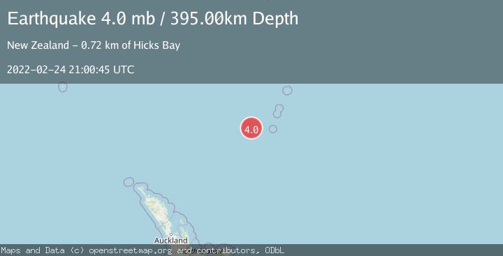
A 4.0 magnitude earthquake struck on KERMADEC ISLANDS REGION, at Thu, 24 Feb 2022 21:00:45 GMT. Depth: 395km. Reviewed by NEIC seismologists, this light quake occurred at a magnitude type of mb.
Magnitude
4.0
mb
Source
NEIC
Intensity
-
Agency Reports
1 Sources| Source | Magnitude | Depth | Time |
|---|---|---|---|
| NEICPrimary | 4.0 | 395 km | 3 years ago |
Earthquake Details
AutomaticEvent IDemsc_NEIC_20220224_0000240
Tsunami PotentialNo
Magnitude Typemb
Nearest Places
- Havre Trough66.8 km
- Havre Seamount107.6 km
- Havre Rock110.4 km
- L'Esperance Rock120.7 km
- Oliver Knoll131.2 km
Comments
Join the discussion about this event.
Latest Earthquakes
2.3Mag
Sulawesi, Indonesia
Time4 minutes ago
Depth0.00 km
SourceVYT (Automatic)
3.5Mag
northern Colombia
Time6 minutes ago
Depth205.20 km
SourceVYT (Automatic)
1.8Mag
Southern California
Time6 minutes ago
Depth22.83 km
SourceVYT (Automatic)
2.1Mag
CENTRAL TURKEY
Time6 minutes ago
Depth5.00 km
SourceKOERI (Automatic)
2.7Mag
Halmahera, Indonesia
Time10 minutes ago
Depth92.18 km
SourceBMKG
Nearby Earthquakes
5.6Mag
KERMADEC ISLANDS REGION
Time2 years ago
Depth446.00 km
SourceEMSC (Automatic)
4.0Mag
KERMADEC ISLANDS REGION
Time7 years ago
Depth433.00 km
SourceNEIC (Automatic)
5.3Mag
KERMADEC ISLANDS REGION
Time1 year ago
Depth432.00 km
SourceEMSC (Automatic)
6.0Mag
KERMADEC ISLANDS REGION
Time8 years ago
Depth386.00 km
SourceEMSC (Automatic)
4.0Mag
KERMADEC ISLANDS REGION
Time2 years ago
Depth300.00 km
SourceGNS (Automatic)