Earthquake SOUTHERN YUKON TERRITORY, CANADA
Wed, 26 Oct 2016 18:31:58 GMT
Time9 years ago
Location
61.5500, -140.9400
Depth
9.0 KM
Event Summary
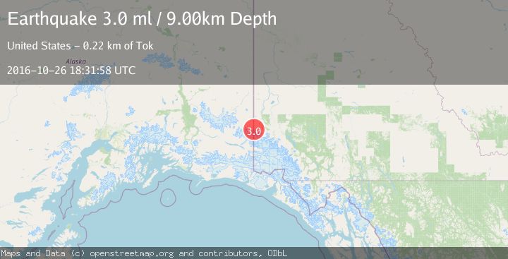
A 3.0 magnitude earthquake struck on SOUTHERN YUKON TERRITORY, CANADA, at Wed, 26 Oct 2016 18:31:58 GMT. Depth: 9km. Reviewed by NEIR seismologists, this minor quake occurred at a magnitude type of ml.
Magnitude
3.0
ml
Source
NEIR
Intensity
-
Agency Reports
1 Sources| Source | Magnitude | Depth | Time |
|---|---|---|---|
| NEIRPrimary | 3.0 | 9 km | 9 years ago |
Earthquake Details
AutomaticEvent IDemsc_NEIR_20161026_0000090
Tsunami PotentialNo
Magnitude Typeml
Nearest Places
- Natazhat Glacier2.6 km
- Mount Lambart3.6 km
- Natazhat Glacier4.9 km
- Brooke Glacier5.2 km
- Mount Brooke6.2 km
Comments
Join the discussion about this event.
Latest Earthquakes
1.5Mag
Southern California
Time19 hours ago
Depth18.43 km
SourceVYT (Automatic)
3.4Mag
south of Alaska
Time20 hours ago
Depth10.00 km
SourceVYT (Automatic)
3.1Mag
Southern California
Time20 hours ago
Depth16.97 km
SourceVYT (Automatic)
2.1Mag
Southern Alaska
Time20 hours ago
Depth71.53 km
SourceVYT (Automatic)
1.5Mag
Southern California
Time20 hours ago
Depth13.67 km
SourceVYT (Automatic)
Nearby Earthquakes
3.0Mag
SOUTHERN ALASKA
Time9 years ago
Depth4.00 km
SourceNEIR (Automatic)
3.0Mag
SOUTHERN YUKON TERRITORY, CANADA
Time3 years ago
Depth4.00 km
SourceNEIC (Automatic)
3.0Mag
SOUTHERN ALASKA
Time10 years ago
Depth1.00 km
SourceNEIC (Automatic)
1.2Mag
96 km E of McCarthy, Alaska
Time2 weeks ago
Depth5.00 km
SourceUSGS (Automatic)
3.0Mag
SOUTHERN YUKON TERRITORY, CANADA
Time8 years ago
Depth9.00 km
SourceNEIR (Automatic)