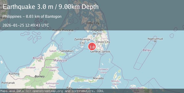
Earthquake MORO GULF, MINDANAO, PHILIPPINES
Sun, 25 Jan 2026 12:49:43 GMT
Time2 days ago
Location
6.6100, 123.7600
Depth
9.0 KM
Event Summary
A 3.0 magnitude earthquake struck on MORO GULF, MINDANAO, PHILIPPINES, at Sun, 25 Jan 2026 12:49:43 GMT. Depth: 9km. Reviewed by PIVS seismologists, this minor quake occurred at a magnitude type of m.
Magnitude
3.0
m
Source
PIVS
Intensity
-
Agency Reports
1 Sources| Source | Magnitude | Depth | Time |
|---|---|---|---|
| PIVSPrimary | 3.0 | 9 km | 2 days ago |
Earthquake Details
AutomaticEvent IDemsc_PIVS_20260125_0000170
Tsunami PotentialNo
Magnitude Typem
Nearest Places
- Huidobro Reef26.0 km
- Donaung Shoals26.6 km
- Linao Point29.4 km
- Salpa Point29.7 km
- Pitas30.0 km
Comments
Join the discussion about this event.
Latest Earthquakes
2.3Mag
Flores Sea
Time21 hours ago
Depth21.75 km
SourceBMKG (Automatic)
2.2Mag
NEVADA
Time21 hours ago
Depth8.30 km
SourceNN (Automatic)
1.8Mag
13 km SSE of Volcano, Hawaii
Time21 hours ago
Depth3.46 km
SourceUSGS (Automatic)
1.4Mag
10 km N of Hollister, CA
Time21 hours ago
Depth10.13 km
SourceUSGS (Automatic)
1.2Mag
13 km WSW of Stanton, Texas
Time21 hours ago
Depth3.46 km
SourceUSGS (Automatic)
Nearby Earthquakes
3.4Mag
MORO GULF, MINDANAO, PHILIPPINES
Time6 days ago
Depth22.00 km
SourcePIVS (Automatic)
3.0Mag
MORO GULF, MINDANAO, PHILIPPINES
Time5 days ago
Depth6.00 km
SourcePIVS (Automatic)
3.1Mag
MORO GULF, MINDANAO, PHILIPPINES
Time3 days ago
Depth19.00 km
SourcePIVS (Automatic)
4.5Mag
Mindanao, Philippines
Time1 day ago
Depth170.01 km
SourceBMKG (Automatic)
3.2Mag
MORO GULF, MINDANAO, PHILIPPINES
Time1 day ago
Depth3.00 km
SourcePIVS (Automatic)