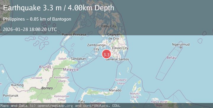
Earthquake MORO GULF, MINDANAO, PHILIPPINES
Wed, 28 Jan 2026 17:42:59 GMT
Time2 hours ago
Location
6.5700, 123.7500
Depth
6.0 KM
Event Summary
A 3.2 magnitude earthquake struck on MORO GULF, MINDANAO, PHILIPPINES, at Wed, 28 Jan 2026 17:42:59 GMT. Depth: 6km. Reviewed by PIVS seismologists, this minor quake occurred at a magnitude type of m.
Magnitude
3.2
m
Source
PIVS
Intensity
-
Agency Reports
1 Sources| Source | Magnitude | Depth | Time |
|---|---|---|---|
| PIVSPrimary | 3.2 | 6 km | 2 hours ago |
Earthquake Details
AutomaticEvent IDemsc_PIVS_20260128_0000328
Tsunami PotentialNo
Magnitude Typem
Nearest Places
- Donaung Shoals26.5 km
- Huidobro Reef29.8 km
- Nara Point30.2 km
- Pidtaguinan Point30.5 km
- Point Pitas31.2 km
Comments
Join the discussion about this event.
Latest Earthquakes
1.8Mag
34 km WSW of Cantwell, Alaska
Time2 hours ago
Depth89.60 km
SourceUSGS (Automatic)
1.3Mag
24 km SW of Snyder, Texas
Time2 hours ago
Depth5.74 km
SourceUSGS (Automatic)
4.1Mag
OFFSHORE O'HIGGINS, CHILE
Time2 hours ago
Depth29.50 km
SourceCSN (Automatic)
1.6Mag
22 km ENE of Chickaloon, Alaska
Time2 hours ago
Depth33.90 km
SourceUSGS (Automatic)
2.0Mag
WESTERN TURKEY
Time2 hours ago
Depth6.70 km
SourceAFAD (Automatic)
Nearby Earthquakes
3.0Mag
MORO GULF, MINDANAO, PHILIPPINES
Time3 days ago
Depth9.00 km
SourcePIVS (Automatic)
4.6Mag
MORO GULF, MINDANAO, PHILIPPINES
Time6 hours ago
Depth6.00 km
SourcePIVS (Automatic)
3.4Mag
MORO GULF, MINDANAO, PHILIPPINES
Time1 week ago
Depth22.00 km
SourcePIVS (Automatic)
3.2Mag
MORO GULF, MINDANAO, PHILIPPINES
Time8 hours ago
Depth10.00 km
SourcePIVS (Automatic)
3.0Mag
MORO GULF, MINDANAO, PHILIPPINES
Time6 days ago
Depth6.00 km
SourcePIVS (Automatic)