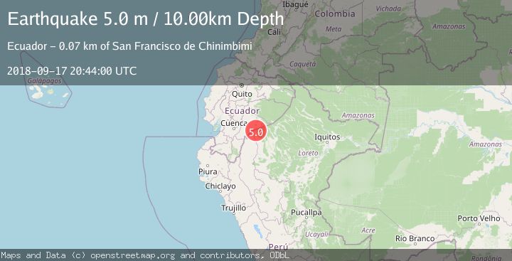
Earthquake PERU-ECUADOR BORDER REGION
Mon, 17 Sep 2018 20:44:00 GMT
Time7 years ago
Location
-3.0300, -77.6500
Depth
10.0 KM
Event Summary
A 5.0 magnitude earthquake struck on PERU-ECUADOR BORDER REGION, at Mon, 17 Sep 2018 20:44:00 GMT. Depth: 10km. Reviewed by RSNC seismologists, this moderate quake occurred at a magnitude type of m.
Magnitude
5.0
m
Source
RSNC
Intensity
-
Agency Reports
1 Sources| Source | Magnitude | Depth | Time |
|---|---|---|---|
| RSNCPrimary | 5.0 | 10 km | 7 years ago |
Earthquake Details
AutomaticEvent IDemsc_RSNC_20180917_0000101
Tsunami PotentialNo
Magnitude Typem
Nearest Places
- Panjilyacu4.5 km
- Borbor6.5 km
- Casa de Chapana7.2 km
- Quebrada Shapaja7.5 km
- Quebrada San Pablo7.8 km
Comments
Join the discussion about this event.
Latest Earthquakes
1.0Mag
Southeastern Alaska
Time6 minutes ago
Depth0.00 km
SourceVYT (Automatic)
3.5Mag
COOK STRAIT, NEW ZEALAND
Time7 minutes ago
Depth75.30 km
SourceGNS (Automatic)
2.5Mag
Seram, Indonesia
Time9 minutes ago
Depth21.28 km
SourceBMKG
2.6Mag
West Papua Region, Indonesia
Time12 minutes ago
Depth17.35 km
SourceBMKG
5.0Mag
CENTRAL MID-ATLANTIC RIDGE
Time12 minutes ago
Depth10.00 km
SourceEMSC (Automatic)
Nearby Earthquakes
5.1Mag
PERU-ECUADOR BORDER REGION
Time10 years ago
Depth30.00 km
SourceEMSC (Automatic)
4.0Mag
PERU-ECUADOR BORDER REGION
Time7 years ago
Depth12.00 km
SourceQUI (Automatic)
4.0Mag
PERU-ECUADOR BORDER REGION
Time4 years ago
Depth5.00 km
SourceQUI (Automatic)
3.5Mag
PERU-ECUADOR BORDER REGION
Time1 day ago
Depth64.00 km
SourceQUI (Automatic)
4.0Mag
PERU-ECUADOR BORDER REGION
Time2 years ago
Depth110.00 km
SourceLIM (Automatic)