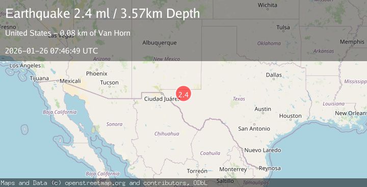
Earthquake WESTERN TEXAS
Mon, 26 Jan 2026 07:46:49 GMT
Time23 hours ago
Location
31.7040, -104.5620
Depth
3.6 KM
Event Summary
A 2.4 magnitude earthquake struck on WESTERN TEXAS, at Mon, 26 Jan 2026 07:46:49 GMT. Depth: 3.6km. Reviewed by TX seismologists, this minor quake occurred at a magnitude type of ml.
Magnitude
2.4
ml
Source
TX
Intensity
-
Agency Reports
2 Sources| Source | Magnitude | Depth | Time |
|---|---|---|---|
| TXPrimary | 2.4 | 4 km | 23 hours ago |
| USGS | 2.4 | 4 km | 23 hours ago |
Earthquake Details
AutomaticEvent IDemsc_TX_20260126_0000131
Tsunami PotentialNo
Magnitude Typeml
Nearest Places
- Red Tank1.1 km
- Nob Hill Tank2.9 km
- Jack Tank3.3 km
- Triangle Ranch Private Airport3.4 km
- Cowden Lake Dam3.6 km
Comments
Join the discussion about this event.
Latest Earthquakes
0.8Mag
6 km WNW of Cobb, CA
Time23 hours ago
Depth1.04 km
SourceUSGS (Automatic)
1.7Mag
CANARY ISLANDS, SPAIN REGION
Time23 hours ago
Depth12.20 km
SourceIGN (Automatic)
2.9Mag
Southern Sumatra, Indonesia
Time23 hours ago
Depth22.12 km
SourceBMKG (Automatic)
0.9Mag
79 km NNW of Karluk, Alaska
Time23 hours ago
Depth5.00 km
SourceUSGS (Automatic)
2.1Mag
Sumbawa Region, Indonesia
Time23 hours ago
Depth20.00 km
SourceBMKG (Automatic)
Nearby Earthquakes
2.1Mag
WESTERN TEXAS
Time1 day ago
Depth3.30 km
SourceTX (Automatic)
2.4Mag
WESTERN TEXAS
Time1 day ago
Depth3.10 km
SourceTX (Automatic)
3.8Mag
WESTERN TEXAS
Time2 days ago
Depth9.60 km
SourceNEIC (Automatic)
2.2Mag
WESTERN TEXAS
Time5 days ago
Depth4.20 km
SourceTX (Automatic)
1.7Mag
61 km SSW of Whites City, New Mexico
Time2 days ago
Depth3.48 km
SourceUSGS (Automatic)