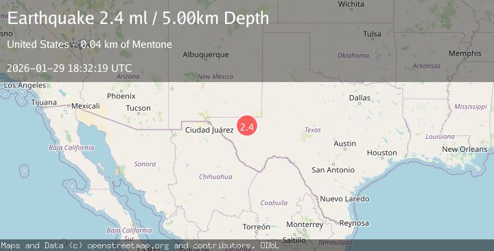
Earthquake WESTERN TEXAS
Thu, 29 Jan 2026 18:32:19 GMT
Time1 hour ago
Location
31.5680, -104.0260
Depth
5.9 KM
Event Summary
A 2.6 magnitude earthquake struck on WESTERN TEXAS, at Thu, 29 Jan 2026 18:32:19 GMT. Depth: 5.9km. Reviewed by TX seismologists, this minor quake occurred at a magnitude type of ml.
Magnitude
2.6
ml
Source
TX
Intensity
-
Agency Reports
1 Sources| Source | Magnitude | Depth | Time |
|---|---|---|---|
| TXPrimary | 2.6 | 6 km | 1 hour ago |
Earthquake Details
AutomaticEvent IDemsc_TX_20260129_0000241
Tsunami PotentialNo
Magnitude Typeml
Nearest Places
- Dry Lake1.8 km
- Rabbit Tank4.3 km
- Derrick Ranch5.0 km
- Cottonwood Tank6.0 km
- Lynn Tank6.2 km
Comments
Join the discussion about this event.
Latest Earthquakes
2.8Mag
West Papua Region, Indonesia
Time1 hour ago
Depth19.31 km
SourceBMKG (Automatic)
1.8Mag
9 km NW of The Geysers, CA
Time1 hour ago
Depth1.95 km
SourceUSGS (Automatic)
1.9Mag
32 km ENE of Boulder City, Nevada
Time2 hours ago
Depth5.75 km
SourceUSGS (Automatic)
3.1Mag
SAN JUAN, ARGENTINA
Time2 hours ago
Depth10.00 km
SourceNSNA (Automatic)
2.4Mag
Minahassa Peninsula, Sulawesi
Time2 hours ago
Depth65.05 km
SourceBMKG (Automatic)
Nearby Earthquakes
1.5Mag
36 km NW of Toyah, Texas
Time4 days ago
Depth5.77 km
SourceUSGS (Automatic)
2.0Mag
WESTERN TEXAS
Time1 week ago
Depth4.30 km
SourceTX (Automatic)
1.7Mag
34 km NW of Toyah, Texas
Time4 days ago
Depth4.59 km
SourceUSGS (Automatic)
1.5Mag
37 km NW of Toyah, Texas
Time1 week ago
Depth6.63 km
SourceUSGS (Automatic)
1.8Mag
33 km NW of Toyah, Texas
Time3 hours ago
Depth8.67 km
SourceUSGS (Automatic)