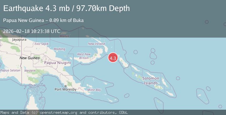
Earthquake NEW IRELAND REGION, P.N.G.
Wed, 18 Feb 2026 10:23:38 GMT
Time2 months ago
Location
-5.5094, 153.8440
Depth
97.7 KM
Event Summary
A 4.3 magnitude earthquake struck on NEW IRELAND REGION, P.N.G., at Wed, 18 Feb 2026 10:23:38 GMT. Depth: 97.7km. Reviewed by NEIC seismologists, this light quake occurred at a magnitude type of mb.
Magnitude
4.3
mb
Source
NEIC
Intensity
I
Agency Reports
1 Sources| Source | Magnitude | Depth | Time |
|---|---|---|---|
| NEICPrimary | 4.3 | 98 km | 2 months ago |
Earthquake Details
AutomaticEvent IDemsc_neic_20260218_0000420
QualityS
Tsunami PotentialNo
Magnitude Typemb
Last Update1 month ago
Nearest Places
- IBuka91.9 km
Felt Reports0
Did you feel this earthquake? Report it to help others.
No reports yet
Be the first to report this earthquake!
Latest Earthquakes
Loading...
Nearby Earthquakes
4.9Mag
New Ireland Region, Papua New Guinea
Time4 days ago
Depth101.93 km
SourceBMKG
5.0Mag
NEW IRELAND REGION, P.N.G.
Time1 week ago
Depth105.00 km
SourceEMSC (Automatic)
4.0Mag
BOUGAINVILLE REGION, P.N.G.
Time2 weeks ago
Depth424.30 km
SourceNEIC (Automatic)
5.3Mag
174 km ESE of Kokopo, Papua New Guinea
Time2 weeks ago
Depth68.01 km
SourceUSGS
4.3Mag
NEW IRELAND REGION, P.N.G.
Time0 months ago
Depth111.10 km
SourceNEIC (Automatic)