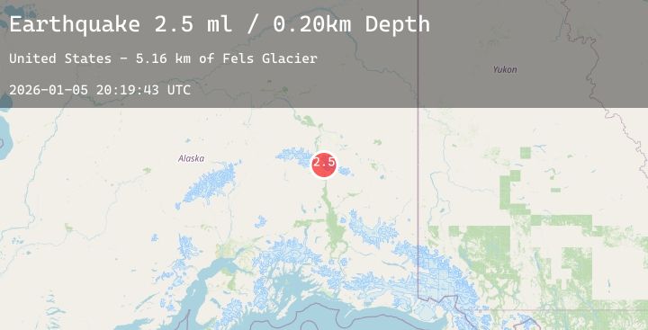
Earthquake 31 km N of Paxson, Alaska
Mon, 05 Jan 2026 20:19:43 GMT
Time4 days ago
Location
63.3660, -145.5250
Depth
5.9 KM
Event Summary
A 2.6 magnitude earthquake struck on 31 km N of Paxson, Alaska, at Mon, 05 Jan 2026 20:19:43 GMT. Depth: 5.9km. Reviewed by USGS seismologists, this minor quake occurred at a magnitude type of ml.
Magnitude
2.6
ml
Source
USGS
Intensity
-
Agency Reports
1 Sources| Source | Magnitude | Depth | Time |
|---|---|---|---|
| USGSPrimary | 2.6 | 6 km | 4 days ago |
Earthquake Details
AutomaticEvent IDusgs_ak2026aixipc
Tsunami PotentialNo
Magnitude Typeml
Nearest Places
- Fels Glacier0.8 km
- Eel Glacier2.3 km
- Traingle Peak4.5 km
- Broken Glacier5.1 km
- M'Ladies Mountain5.5 km
Comments
Join the discussion about this event.
Latest Earthquakes
2.4Mag
South of Bali, Indonesia
Time4 days ago
Depth25.47 km
SourceBMKG (Automatic)
2.0Mag
SICILY, ITALY
Time4 days ago
Depth19.30 km
SourceINGV (Automatic)
2.5Mag
CENTRAL TURKEY
Time4 days ago
Depth5.90 km
SourceEMSC (Automatic)
2.1Mag
Southern Sumatra, Indonesia
Time4 days ago
Depth2.75 km
SourceBMKG (Automatic)
1.8Mag
5 km N of Dublin, CA
Time4 days ago
Depth7.63 km
SourceUSGS (Automatic)
Nearby Earthquakes
No significant earthquakes nearby recently.