Earthquake 44 km NW of Tatitlek, Alaska
Tue, 06 Jan 2026 15:01:08 GMT
Time1 day ago
Location
61.1660, -147.2300
Depth
5.0 KM
Event Summary
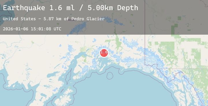
A 1.6 magnitude earthquake struck on 44 km NW of Tatitlek, Alaska, at Tue, 06 Jan 2026 15:01:08 GMT. Depth: 5km. Reviewed by USGS seismologists, this minor quake occurred at a magnitude type of ml.
Magnitude
1.6
ml
Source
USGS
Intensity
-
Agency Reports
1 Sources| Source | Magnitude | Depth | Time |
|---|---|---|---|
| USGSPrimary | 1.6 | 5 km | 1 day ago |
Earthquake Details
AutomaticEvent IDusgs_ak2026akimyd
Tsunami PotentialNo
Magnitude Typeml
Nearest Places
- Pedro Glacier5.9 km
- First Branch Columbia Glacier (not official)7.1 km
- Kadin Lake7.4 km
- Columbia Peak8.8 km
- Mount Grosvenor10.7 km
Comments
Join the discussion about this event.
Latest Earthquakes
2.9Mag
West Papua, Indonesia
Time1 day ago
Depth10.00 km
SourceBMKG (Automatic)
2.1Mag
NEVADA
Time1 day ago
Depth3.50 km
SourceNN (Automatic)
2.0Mag
58 km ENE of Cantwell, Alaska
Time1 day ago
Depth1.20 km
SourceUSGS (Automatic)
2.4Mag
Seram, Indonesia
Time1 day ago
Depth1.03 km
SourceBMKG (Automatic)
2.4Mag
Java, Indonesia
Time1 day ago
Depth12.19 km
SourceBMKG (Automatic)