Earthquake 113 km S of McCarthy, Alaska
Mon, 26 Jan 2026 15:58:37 GMT
Time22 hours ago
Location
60.4150, -142.9430
Depth
12.1 KM
Event Summary
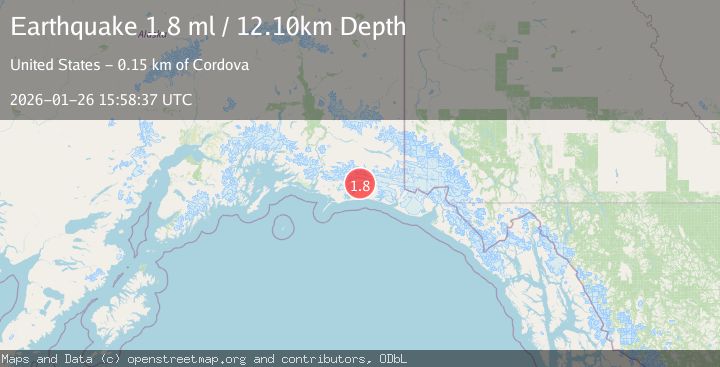
A 1.8 magnitude earthquake struck on 113 km S of McCarthy, Alaska, at Mon, 26 Jan 2026 15:58:37 GMT. Depth: 12.1km. Reviewed by USGS seismologists, this minor quake occurred at a magnitude type of ml.
Magnitude
1.8
ml
Source
USGS
Intensity
-
Agency Reports
1 Sources| Source | Magnitude | Depth | Time |
|---|---|---|---|
| USGSPrimary | 1.8 | 12 km | 22 hours ago |
Earthquake Details
AutomaticEvent IDusgs_ak2026bvcybu
Tsunami PotentialNo
Magnitude Typeml
Nearest Places
- Ovtsyn Glacier5.6 km
- Central Valley Reach6.0 km
- Bering Glacier System6.1 km
- Betge Glacier6.7 km
- Waxell Ridge11.4 km
Comments
Join the discussion about this event.
Latest Earthquakes
2.6Mag
Minahassa Peninsula, Sulawesi
Time17 hours ago
Depth118.00 km
SourceBMKG (Automatic)
2.8Mag
South of Bali, Indonesia
Time17 hours ago
Depth10.00 km
SourceBMKG (Automatic)
1.7Mag
31 km SE of Denali National Park, Alaska
Time17 hours ago
Depth0.60 km
SourceUSGS (Automatic)
2.2Mag
WESTERN TURKEY
Time17 hours ago
Depth14.90 km
SourceKOERI (Automatic)
2.2Mag
13 km NW of Ferry, Alaska
Time17 hours ago
Depth139.50 km
SourceUSGS (Automatic)
Nearby Earthquakes
0.7Mag
100 km SSE of McCarthy, Alaska
Time4 days ago
Depth37.40 km
SourceUSGS (Automatic)
1.1Mag
112 km E of Cordova, Alaska
Time4 days ago
Depth13.00 km
SourceUSGS (Automatic)
1.1Mag
86 km SSW of McCarthy, Alaska
Time1 day ago
Depth5.00 km
SourceUSGS (Automatic)
1.0Mag
127 km NW of Yakutat, Alaska
Time1 day ago
Depth19.90 km
SourceUSGS (Automatic)
0.8Mag
120 km NW of Yakutat, Alaska
Time3 days ago
Depth5.00 km
SourceUSGS (Automatic)