Earthquake 127 km NW of Yakutat, Alaska
Mon, 26 Jan 2026 13:01:10 GMT
Time19 hours ago
Location
60.3370, -141.3720
Depth
19.9 KM
Event Summary
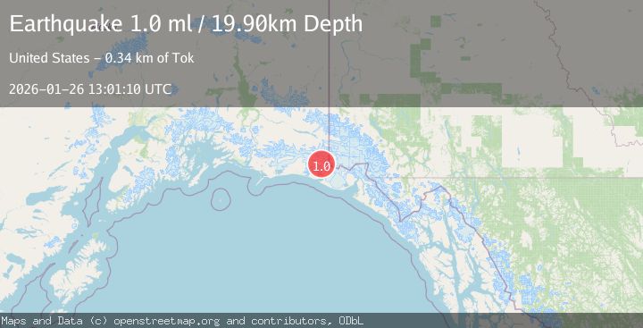
A 1.0 magnitude earthquake struck on 127 km NW of Yakutat, Alaska, at Mon, 26 Jan 2026 13:01:10 GMT. Depth: 19.9km. Reviewed by USGS seismologists, this minor quake occurred at a magnitude type of ml.
Magnitude
1.0
ml
Source
USGS
Intensity
-
Agency Reports
1 Sources| Source | Magnitude | Depth | Time |
|---|---|---|---|
| USGSPrimary | 1.0 | 20 km | 19 hours ago |
Earthquake Details
AutomaticEvent IDusgs_ak2026buxbeg
Tsunami PotentialNo
Magnitude Typeml
Nearest Places
- Mount Huxley12.3 km
- Crater Basin13.7 km
- Guyot Hills15.4 km
- Coal Glacier15.8 km
- The Hump16.3 km
Comments
Join the discussion about this event.
Latest Earthquakes
2.6Mag
Minahassa Peninsula, Sulawesi
Time12 hours ago
Depth118.00 km
SourceBMKG (Automatic)
2.8Mag
South of Bali, Indonesia
Time12 hours ago
Depth10.00 km
SourceBMKG (Automatic)
1.7Mag
31 km SE of Denali National Park, Alaska
Time12 hours ago
Depth0.60 km
SourceUSGS (Automatic)
2.2Mag
WESTERN TURKEY
Time12 hours ago
Depth14.90 km
SourceKOERI (Automatic)
2.2Mag
13 km NW of Ferry, Alaska
Time12 hours ago
Depth139.50 km
SourceUSGS (Automatic)
Nearby Earthquakes
0.8Mag
120 km NW of Yakutat, Alaska
Time3 days ago
Depth5.00 km
SourceUSGS (Automatic)
2.2Mag
110 km NW of Yakutat, Alaska
Time3 days ago
Depth16.90 km
SourceUSGS (Automatic)
1.6Mag
102 km NW of Yakutat, Alaska
Time1 day ago
Depth15.10 km
SourceUSGS (Automatic)
2.1Mag
111 km WNW of Yakutat, Alaska
Time3 days ago
Depth8.00 km
SourceUSGS (Automatic)
2.6Mag
96 km WNW of Yakutat, Alaska
Time5 days ago
Depth4.10 km
SourceUSGS (Automatic)