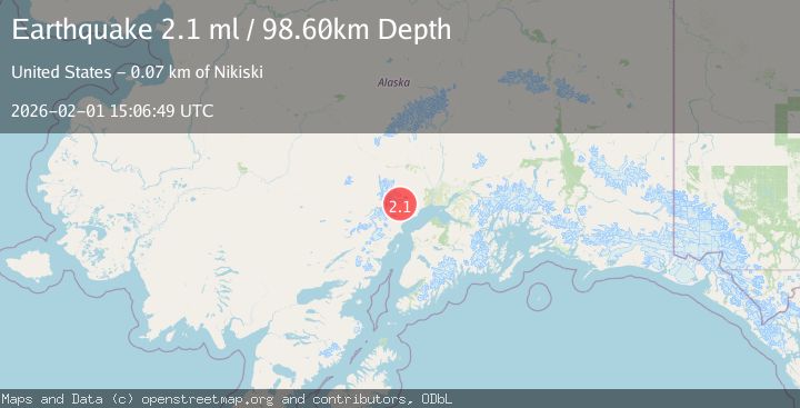
Earthquake 43 km WNW of Beluga, Alaska
Sun, 01 Feb 2026 15:06:49 GMT
Time1 day ago
Location
61.2820, -151.8290
Depth
98.6 KM
Event Summary
A 2.1 magnitude earthquake struck on 43 km WNW of Beluga, Alaska, at Sun, 01 Feb 2026 15:06:49 GMT. Depth: 98.6km. Reviewed by USGS seismologists, this minor quake occurred at a magnitude type of ml.
Magnitude
2.1
ml
Source
USGS
Intensity
-
Agency Reports
1 Sources| Source | Magnitude | Depth | Time |
|---|---|---|---|
| USGSPrimary | 2.1 | 99 km | 1 day ago |
Earthquake Details
AutomaticEvent IDusgs_ak2026cgborq
Tsunami PotentialNo
Magnitude Typeml
Nearest Places
- Capps Glacier6.5 km
- North Capps Creek8.8 km
- Capps Glacier9.7 km
- Wolverine Fork12.8 km
- Capps Creek12.8 km
Comments
Join the discussion about this event.
Latest Earthquakes
0.7Mag
7 km NW of The Geysers, CA
Time56 minutes ago
Depth3.13 km
SourceUSGS (Automatic)
2.4Mag
Sumba Region, Indonesia
Time1 hour ago
Depth17.48 km
SourceBMKG (Automatic)
2.1Mag
73 km WNW of Ninilchik, Alaska
Time1 hour ago
Depth128.00 km
SourceUSGS (Automatic)
2.4Mag
Southern Sumatra, Indonesia
Time1 hour ago
Depth10.00 km
SourceBMKG (Automatic)
2.5Mag
Sumbawa Region, Indonesia
Time1 hour ago
Depth77.93 km
SourceBMKG (Automatic)
Nearby Earthquakes
2.1Mag
49 km WNW of Beluga, Alaska
Time12 hours ago
Depth103.90 km
SourceUSGS (Automatic)
0.8Mag
57 km WNW of Tyonek, Alaska
Time1 week ago
Depth115.90 km
SourceUSGS (Automatic)
3.1Mag
SOUTHERN ALASKA
Time1 week ago
Depth5.00 km
SourceAK (Automatic)
2.2Mag
56 km W of Tyonek, Alaska
Time1 week ago
Depth110.90 km
SourceUSGS (Automatic)
2.3Mag
34 km NW of Beluga, Alaska
Time5 days ago
Depth83.70 km
SourceUSGS (Automatic)