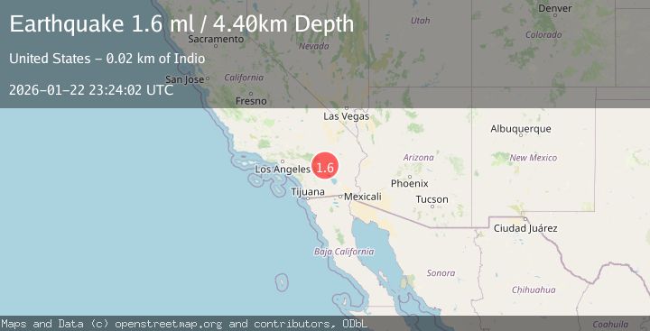
Earthquake 19 km N of Indio, CA
Thu, 22 Jan 2026 22:32:01 GMT
Time4 days ago
Location
33.8910, -116.1748
Depth
2.9 KM
Event Summary
A 1.6 magnitude earthquake struck on 19 km N of Indio, CA, at Thu, 22 Jan 2026 22:32:01 GMT. Depth: 2.89000010490417km. Reviewed by USGS seismologists, this minor quake occurred at a magnitude type of ml.
Magnitude
1.6
ml
Source
USGS
Intensity
-
Agency Reports
1 Sources| Source | Magnitude | Depth | Time |
|---|---|---|---|
| USGSPrimary | 1.6 | 4 km | 4 days ago |
Earthquake Details
AutomaticEvent IDusgs_ci41168687
Tsunami PotentialNo
Magnitude Typeml
Nearest Places
- Cabezon Indian Reservation2.7 km
- Hidden Gold Mine3.8 km
- The Blue Cut3.8 km
- Keys View4.1 km
- KPLM-FM (Palm Springs)5.4 km
Comments
Join the discussion about this event.
Latest Earthquakes
1.1Mag
30 km NE of Los Alamos, CA
Time12 minutes ago
Depth4.17 km
SourceUSGS (Automatic)
1.2Mag
EASTERN TURKEY
Time12 minutes ago
Depth7.00 km
SourceAFAD (Automatic)
2.6Mag
Timor Region
Time15 minutes ago
Depth35.26 km
SourceBMKG (Automatic)
2.3Mag
Sumbawa Region, Indonesia
Time15 minutes ago
Depth10.00 km
SourceBMKG (Automatic)
2.5Mag
Flores Sea
Time17 minutes ago
Depth26.93 km
SourceBMKG (Automatic)
Nearby Earthquakes
2.6Mag
SOUTHERN CALIFORNIA
Time3 days ago
Depth3.70 km
SourceSCSN (Automatic)
2.8Mag
SOUTHERN CALIFORNIA
Time6 days ago
Depth2.30 km
SourceSCSN (Automatic)
0.8Mag
20 km NNE of Indio, CA
Time2 days ago
Depth5.32 km
SourceUSGS (Automatic)
2.1Mag
SOUTHERN CALIFORNIA
Time3 days ago
Depth4.90 km
SourceSCSN (Automatic)
2.8Mag
SOUTHERN CALIFORNIA
Time5 days ago
Depth2.50 km
SourceSCSN (Automatic)