Earthquake 21 km N of Yucca Valley, CA
Sat, 24 Jan 2026 17:06:32 GMT
Time2 days ago
Location
34.3058, -116.4507
Depth
7.3 KM
Event Summary
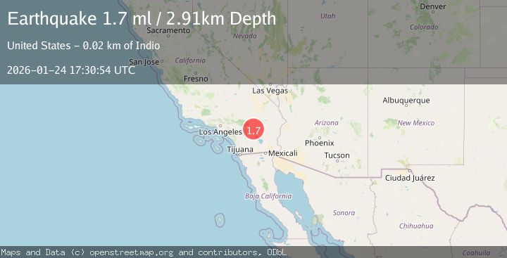
A 1.7 magnitude earthquake struck on 21 km N of Yucca Valley, CA, at Sat, 24 Jan 2026 17:06:32 GMT. Depth: 7.26999998092651km. Reviewed by USGS seismologists, this minor quake occurred at a magnitude type of ml.
Magnitude
1.7
ml
Source
USGS
Intensity
-
Agency Reports
1 Sources| Source | Magnitude | Depth | Time |
|---|---|---|---|
| USGSPrimary | 1.7 | 3 km | 2 days ago |
Earthquake Details
AutomaticEvent IDusgs_ci41170935
Tsunami PotentialNo
Magnitude Typeml
Nearest Places
Comments
Join the discussion about this event.
Latest Earthquakes
1.4Mag
41 km NW of Toyah, Texas
Time4 minutes ago
Depth2.74 km
SourceUSGS (Automatic)
2.0Mag
Sumbawa Region, Indonesia
Time9 minutes ago
Depth107.77 km
SourceBMKG (Automatic)
1.7Mag
26 km WNW of Ludlow, CA
Time13 minutes ago
Depth1.36 km
SourceUSGS (Automatic)
3.1Mag
HAITI REGION
Time15 minutes ago
Depth7.00 km
SourceAYIT (Automatic)
2.6Mag
PUERTO RICO
Time21 minutes ago
Depth16.10 km
SourcePR (Automatic)
Nearby Earthquakes
1.1Mag
13 km NE of Big Bear City, CA
Time6 hours ago
Depth3.01 km
SourceUSGS (Automatic)
1.0Mag
4 km NNW of Big Bear City, CA
Time1 day ago
Depth3.61 km
SourceUSGS (Automatic)
2.3Mag
SOUTHERN CALIFORNIA
Time1 day ago
Depth3.50 km
SourceSCSN (Automatic)
2.1Mag
9 km WSW of Garnet, CA
Time3 days ago
Depth16.09 km
SourceUSGS (Automatic)
1.4Mag
8 km NNE of Banning, CA
Time2 days ago
Depth12.57 km
SourceUSGS (Automatic)