Earthquake 10 km WSW of Pepeekeo, Hawaii
Tue, 27 Jan 2026 11:02:45 GMT
Time3 hours ago
Location
19.8132, -155.2053
Depth
36.5 KM
Event Summary
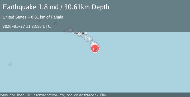
A 1.8 magnitude earthquake struck on 10 km WSW of Pepeekeo, Hawaii, at Tue, 27 Jan 2026 11:02:45 GMT. Depth: 36.4799995422363km. Reviewed by USGS seismologists, this minor quake occurred at a magnitude type of md.
Magnitude
1.8
md
Source
USGS
Intensity
-
Agency Reports
1 Sources| Source | Magnitude | Depth | Time |
|---|---|---|---|
| USGSPrimary | 1.8 | 31 km | 2 hours ago |
Earthquake Details
AutomaticEvent IDusgs_hv74886242
Tsunami PotentialNo
Magnitude Typemd
Nearest Places
- Makahanaloa1.5 km
- Pāpa‘ikou1.6 km
- Pauka‘a4.3 km
- Hakalau Nui4.6 km
- Waiemi Falls4.7 km
Comments
Join the discussion about this event.
Latest Earthquakes
1.4Mag
41 km NW of Toyah, Texas
Time5 minutes ago
Depth2.74 km
SourceUSGS (Automatic)
2.0Mag
Sumbawa Region, Indonesia
Time10 minutes ago
Depth107.77 km
SourceBMKG (Automatic)
1.7Mag
26 km WNW of Ludlow, CA
Time14 minutes ago
Depth1.36 km
SourceUSGS (Automatic)
3.1Mag
HAITI REGION
Time16 minutes ago
Depth7.00 km
SourceAYIT (Automatic)
2.6Mag
PUERTO RICO
Time22 minutes ago
Depth16.10 km
SourcePR (Automatic)
Nearby Earthquakes
2.2Mag
ISLAND OF HAWAII, HAWAII
Time6 days ago
Depth-0.20 km
SourceHV (Automatic)
1.9Mag
5 km WSW of Volcano, Hawaii
Time4 days ago
Depth0.24 km
SourceUSGS (Automatic)
1.7Mag
Hawaii
Time1 week ago
Depth1.79 km
SourceUSGS (Automatic)
2.1Mag
ISLAND OF HAWAII, HAWAII
Time4 days ago
Depth6.60 km
SourceHV (Automatic)
2.0Mag
12 km SW of Pāhoa, Hawaii
Time2 days ago
Depth0.88 km
SourceUSGS (Automatic)