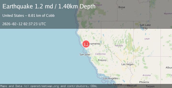
Earthquake 5 km NNW of The Geysers, CA
Thu, 12 Feb 2026 02:37:23 GMT
Time1 week ago
Location
38.8152, -122.7815
Depth
1.4 KM
Event Summary
A 1.2 magnitude earthquake struck on 5 km NNW of The Geysers, CA, at Thu, 12 Feb 2026 02:37:23 GMT. Depth: 1.39999997615814km. Reviewed by USGS seismologists, this minor quake occurred at a magnitude type of md.
Magnitude
1.2
md
Source
USGS
Intensity
-
Agency Reports
1 Sources| Source | Magnitude | Depth | Time |
|---|---|---|---|
| USGSPrimary | 1.2 | 1 km | 1 week ago |
Earthquake Details
AutomaticEvent IDusgs_nc75312392
Tsunami PotentialNo
Magnitude Typemd
Nearest Places
- Geyser Rock1.3 km
- Burned Mountain2.2 km
- Lee Creek2.6 km
- Cobb Creek2.7 km
- Geyser Canyon2.8 km
Comments
Join the discussion about this event.
Latest Earthquakes
1.2Mag
Alaska Peninsula
Time18 hours ago
Depth0.12 km
SourceVYT (Automatic)
3.1Mag
DODECANESE IS.-TURKEY BORDER REG
Time18 hours ago
Depth4.10 km
SourceKOERI (Automatic)
2.6Mag
NEAR COAST OF NICARAGUA
Time18 hours ago
Depth38.00 km
SourceINET (Automatic)
1.4Mag
Central Alaska
Time18 hours ago
Depth110.35 km
SourceVYT (Automatic)
1.3Mag
Southeastern Alaska
Time19 hours ago
Depth0.00 km
SourceVYT (Automatic)
Nearby Earthquakes
0.8Mag
5 km NNW of The Geysers, CA
Time3 weeks ago
Depth1.22 km
SourceUSGS (Automatic)
1.4Mag
5 km NNW of The Geysers, CA
Time2 weeks ago
Depth1.68 km
SourceUSGS (Automatic)
1.1Mag
5 km NNW of The Geysers, CA
Time2 weeks ago
Depth1.56 km
SourceUSGS (Automatic)
2.2Mag
NORTHERN CALIFORNIA
Time1 month ago
Depth2.70 km
SourceNC (Automatic)
2.4Mag
NORTHERN CALIFORNIA
Time6 days ago
Depth1.60 km
SourceNC (Automatic)