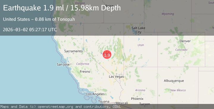
Earthquake 75 km NE of Tonopah, Nevada
Mon, 02 Mar 2026 05:27:17 GMT
Time1 hour ago
Location
38.4659, -116.5367
Depth
16.0 KM
Event Summary
A 1.9 magnitude earthquake struck on 75 km NE of Tonopah, Nevada, at Mon, 02 Mar 2026 05:27:17 GMT. Depth: 15.9816km. Reviewed by USGS seismologists, this minor quake occurred at a magnitude type of ml.
Magnitude
1.9
ml
Source
USGS
Intensity
-
Agency Reports
1 Sources| Source | Magnitude | Depth | Time |
|---|---|---|---|
| USGSPrimary | 1.9 | 16 km | 1 hour ago |
Earthquake Details
AutomaticEvent IDusgs_nn00911603
Tsunami PotentialNo
Magnitude Typeml
Nearest Places
- 2.5 km
- 4.4 km
- 7.3 km
- 7.8 km
- 8.5 km
Comments
Join the discussion about this event.
Latest Earthquakes
1.1Mag
23 km N of Borrego Springs, CA
Time59 minutes ago
Depth6.07 km
SourceUSGS (Automatic)
0.6Mag
8 km NW of The Geysers, CA
Time59 minutes ago
Depth1.73 km
SourceUSGS (Automatic)
2.7Mag
Southern Sumatra, Indonesia
Time59 minutes ago
Depth5.40 km
SourceBMKG
3.8Mag
Halmahera, Indonesia
Time1 hour ago
Depth189.09 km
SourceVYT (Automatic)
2.6Mag
Libertador General Bernardo O'Higgins, Chile
Time1 hour ago
Depth23.19 km
SourceVYT (Automatic)
Nearby Earthquakes
1.6Mag
75 km NE of Tonopah, Nevada
Time11 hours ago
Depth16.00 km
SourceUSGS (Automatic)
2.4Mag
76 km NE of Tonopah, Nevada
Time9 hours ago
Depth4.05 km
SourceUSGS (Automatic)
3.1Mag
NEVADA
Time9 hours ago
Depth5.00 km
SourceNN (Automatic)
1.6Mag
77 km NE of Tonopah, Nevada
Time6 hours ago
Depth15.79 km
SourceUSGS (Automatic)
1.6Mag
78 km NE of Tonopah, Nevada
Time1 day ago
Depth13.79 km
SourceUSGS (Automatic)