Earthquake 47 km WNW of Toyah, Texas
Fri, 13 Feb 2026 07:30:29 GMT
Time5 days ago
Location
31.4700, -104.2560
Depth
1.4 KM
Event Summary
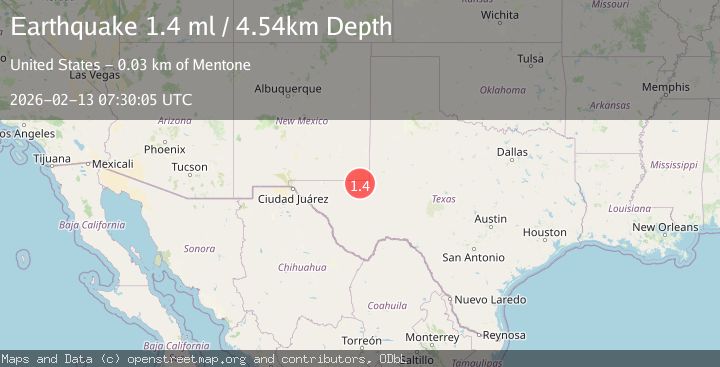
A 1.4 magnitude earthquake struck on 47 km WNW of Toyah, Texas, at Fri, 13 Feb 2026 07:30:29 GMT. Depth: 1.3782km. Reviewed by USGS seismologists, this minor quake occurred at a magnitude type of ml.
Magnitude
1.4
ml
Source
USGS
Intensity
-
Agency Reports
1 Sources| Source | Magnitude | Depth | Time |
|---|---|---|---|
| USGSPrimary | 1.4 | 5 km | 5 days ago |
Earthquake Details
AutomaticEvent IDusgs_tx2026dbndow
Tsunami PotentialNo
Magnitude Typeml
Nearest Places
- Digger Windmill3.9 km
- Dellahunt Draw3.9 km
- Frosty Tank4.9 km
- Sulphur Windmill5.7 km
- Orchard Windmill5.8 km
Comments
Join the discussion about this event.
Latest Earthquakes
2.4Mag
Finland
Time2 minutes ago
Depth301.88 km
SourceVYT (Automatic)
1.2Mag
Alaska Peninsula
Time2 minutes ago
Depth0.12 km
SourceVYT (Automatic)
3.1Mag
DODECANESE IS.-TURKEY BORDER REG
Time8 minutes ago
Depth4.10 km
SourceKOERI (Automatic)
2.6Mag
NEAR COAST OF NICARAGUA
Time13 minutes ago
Depth38.00 km
SourceINET (Automatic)
1.4Mag
Central Alaska
Time16 minutes ago
Depth110.35 km
SourceVYT (Automatic)
Nearby Earthquakes
1.7Mag
48 km WNW of Toyah, Texas
Time1 day ago
Depth0.00 km
SourceUSGS (Automatic)
2.0Mag
WESTERN TEXAS
Time1 month ago
Depth0.00 km
SourceTX (Automatic)
2.3Mag
western Texas
Time2 days ago
Depth22.95 km
SourceVYT (Automatic)
1.3Mag
40 km WNW of Toyah, Texas
Time1 week ago
Depth2.72 km
SourceUSGS (Automatic)
3.0Mag
WESTERN TEXAS
Time1 year ago
Depth6.70 km
SourceNEIC (Automatic)