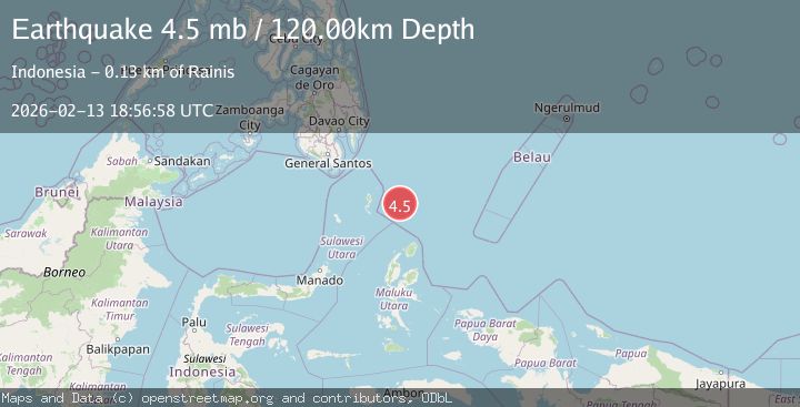
Earthquake 282 km N of Tobelo, Indonesia
Fri, 13 Feb 2026 18:56:59 GMT
Time5 days ago
Location
4.2841, 128.0566
Depth
120.8 KM
Event Summary
A 4.5 magnitude earthquake struck on 282 km N of Tobelo, Indonesia, at Fri, 13 Feb 2026 18:56:59 GMT. Depth: 120.756km. Reviewed by USGS seismologists, this light quake occurred at a magnitude type of mb.
Magnitude
4.5
mb
Source
USGS
Intensity
-
Agency Reports
2 Sources| Source | Magnitude | Depth | Time |
|---|---|---|---|
| USGSPrimary | 4.5 | 121 km | 5 days ago |
| EMSC | 4.5 | 120 km | 5 days ago |
Earthquake Details
ConfirmedEvent IDusgs_us6000s91r
Tsunami PotentialNo
Magnitude Typemb
Nearest Places
- Snellius Ridge32.2 km
- Talaud Trough77.7 km
- Pulau Kakorotan106.5 km
- Desa Kakorotan106.5 km
- Pulau Intata107.3 km
Comments
Join the discussion about this event.
Latest Earthquakes
1.8Mag
British Columbia, Canada
Time12 hours ago
Depth9.03 km
SourceVYT (Automatic)
1.7Mag
Southern Alaska
Time12 hours ago
Depth67.63 km
SourceVYT (Automatic)
1.6Mag
British Columbia, Canada
Time12 hours ago
Depth16.97 km
SourceVYT (Automatic)
3.3Mag
Salta, Argentina
Time12 hours ago
Depth197.88 km
SourceVYT (Automatic)
1.9Mag
British Columbia, Canada
Time12 hours ago
Depth0.98 km
SourceVYT (Automatic)
Nearby Earthquakes
4.0Mag
NORTH OF HALMAHERA, INDONESIA
Time2 years ago
Depth73.00 km
SourcePIVS (Automatic)
4.5Mag
north of Halmahera, Indonesia
Time4 days ago
Depth10.00 km
SourceVYT (Automatic)
4.8Mag
North of Halmahera, Indonesia
Time4 days ago
Depth14.19 km
SourceBMKG
4.1Mag
North of Halmahera, Indonesia
Time2 days ago
Depth10.00 km
SourceBMKG
5.1Mag
KEPULAUAN TALAUD, INDONESIA
Time3 months ago
Depth131.60 km
SourceEMSC (Automatic)