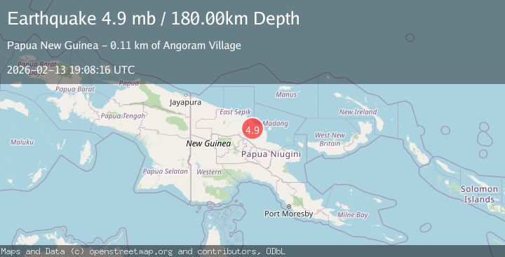
Earthquake near the north coast of New Guinea, Papua New Guinea
Fri, 13 Feb 2026 19:08:17 GMT
Time6 days ago
Location
-4.6867, 144.9415
Depth
187.6 KM
Event Summary
A 5.0 magnitude earthquake struck on near the north coast of New Guinea, Papua New Guinea, at Fri, 13 Feb 2026 19:08:17 GMT. Depth: 187.6220703125km. Reviewed by VYT seismologists, this moderate quake occurred at a magnitude type of earthquake.
Magnitude
5.0
earthquake
Source
VYT
Intensity
-
Agency Reports
5 Sources| Source | Magnitude | Depth | Time |
|---|---|---|---|
| VYTPrimary | 5.0 | 188 km | 6 days ago |
| BMKG | 4.8 | 169 km | 6 days ago |
| NEIC | 4.9 | 185 km | 6 days ago |
| USGS | 4.9 | 185 km | 6 days ago |
| EMSC | 4.9 | 180 km | 6 days ago |
Earthquake Details
AutomaticEvent IDvyt_11susds2tm1ob
Tsunami PotentialNo
Magnitude Typeearthquake
Nearest Places
- Waiutang4.7 km
- Mindivi4.7 km
- Pondoma Area6.4 km
- Ambok6.5 km
- Ikundum6.5 km
Comments
Join the discussion about this event.
Latest Earthquakes
1.3Mag
8 km NW of The Geysers, CA
Time9 hours ago
Depth1.51 km
SourceUSGS (Automatic)
2.2Mag
Southeastern Alaska
Time9 hours ago
Depth0.00 km
SourceVYT (Automatic)
1.9Mag
Tarapaca, Chile
Time10 hours ago
Depth107.06 km
SourceVYT (Automatic)
3.0Mag
Java, Indonesia
Time10 hours ago
Depth0.00 km
SourceVYT (Automatic)
5.1Mag
PHILIPPINE ISLANDS REGION
Time10 hours ago
Depth10.00 km
SourceGFZ (Automatic)
Nearby Earthquakes
5.2Mag
NEAR N COAST OF NEW GUINEA, PNG.
Time7 years ago
Depth69.00 km
SourceEMSC (Automatic)
5.6Mag
NEAR N COAST OF NEW GUINEA, PNG.
Time8 years ago
Depth70.00 km
SourceEMSC (Automatic)
5.3Mag
NEAR N COAST OF NEW GUINEA, PNG.
Time5 years ago
Depth30.00 km
SourceEMSC (Automatic)
4.0Mag
NEAR N COAST OF NEW GUINEA, PNG.
Time2 years ago
Depth71.60 km
SourceNEIC (Automatic)
4.0Mag
NEAR N COAST OF NEW GUINEA, PNG.
Time5 years ago
Depth5.00 km
SourceNEIC (Automatic)