Earthquake Kepulauan Talaud, Indonesia
Fri, 13 Feb 2026 21:49:41 GMT
Time6 days ago
Location
4.0445, 126.6535
Depth
84.7 KM
Event Summary
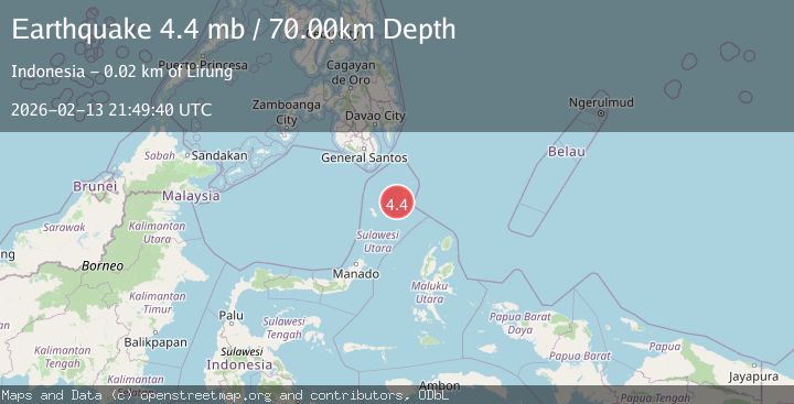
A 4.8 magnitude earthquake struck on Kepulauan Talaud, Indonesia, at Fri, 13 Feb 2026 21:49:41 GMT. Depth: 84.716796875km. Reviewed by VYT seismologists, this light quake occurred at a magnitude type of earthquake.
Magnitude
4.8
earthquake
Source
VYT
Intensity
-
Agency Reports
5 Sources| Source | Magnitude | Depth | Time |
|---|---|---|---|
| VYTPrimary | 4.8 | 85 km | 6 days ago |
| BMKG | 4.6 | 55 km | 6 days ago |
| NEIC | 4.4 | 75 km | 6 days ago |
| USGS | 4.4 | 74 km | 6 days ago |
| EMSC | 4.4 | 70 km | 6 days ago |
Earthquake Details
AutomaticEvent IDvyt_18c4h851nzvbz
Tsunami PotentialNo
Magnitude Typeearthquake
Nearest Places
- Tanjung Binawing1.6 km
- Sawang2.8 km
- Desa Sawang3.1 km
- Desa Kalongan3.3 km
- Kelurahan Melonguane Barat3.5 km
Comments
Join the discussion about this event.
Latest Earthquakes
3.7Mag
Molucca Sea
Time1 minute ago
Depth29.79 km
SourceVYT (Automatic)
1.9Mag
6 km NW of Pinnacles, CA
Time5 minutes ago
Depth4.82 km
SourceUSGS (Automatic)
1.2Mag
Southern Yukon Territory, Canada
Time16 minutes ago
Depth0.00 km
SourceVYT (Automatic)
3.6Mag
Jujuy, Argentina
Time17 minutes ago
Depth228.27 km
SourceVYT (Automatic)
1.3Mag
2 km N of The Geysers, CA
Time24 minutes ago
Depth0.17 km
SourceUSGS (Automatic)
Nearby Earthquakes
2.7Mag
KEPULAUAN TALAUD, INDONESIA
Time1 month ago
Depth16.00 km
SourceBMKG (Automatic)
2.9Mag
KEPULAUAN TALAUD, INDONESIA
Time1 month ago
Depth45.00 km
SourceBMKG (Automatic)
5.4Mag
KEPULAUAN TALAUD, INDONESIA
Time17 years ago
Depth40.00 km
SourceEMSC (Automatic)
5.4Mag
KEPULAUAN TALAUD, INDONESIA
Time3 months ago
Depth39.60 km
SourceEMSC (Automatic)
5.5Mag
KEPULAUAN TALAUD, INDONESIA
Time19 years ago
Depth10.00 km
SourceEMSC (Automatic)