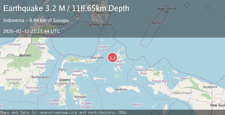
Earthquake Halmahera, Indonesia
Thu, 12 Feb 2026 21:25:44 GMT
Time5 days ago
Location
1.1853, 127.0483
Depth
125.7 KM
Event Summary
A 3.6 magnitude earthquake struck on Halmahera, Indonesia, at Thu, 12 Feb 2026 21:25:44 GMT. Depth: 125.732421875km. Reviewed by VYT seismologists, this minor quake occurred at a magnitude type of earthquake.
Magnitude
3.6
earthquake
Source
VYT
Intensity
-
Agency Reports
2 Sources| Source | Magnitude | Depth | Time |
|---|---|---|---|
| VYTPrimary | 3.6 | 126 km | 5 days ago |
| BMKG | 3.2 | 119 km | 5 days ago |
Earthquake Details
AutomaticEvent IDvyt_22tr6xbn2bdb6
Tsunami PotentialNo
Magnitude Typeearthquake
Nearest Places
- Nyi37.0 km
- Tanjung Roromadehe39.2 km
- Desa Todahe39.9 km
- Todahe40.1 km
- Peot40.1 km
Comments
Join the discussion about this event.
Latest Earthquakes
2.9Mag
near the coast of Tarapaca, Chile
Time59 minutes ago
Depth33.08 km
SourceVYT (Automatic)
2.4Mag
Java, Indonesia
Time1 hour ago
Depth32.97 km
SourceBMKG
2.3Mag
56 km SSE of Perryville, Alaska
Time1 hour ago
Depth34.70 km
SourceUSGS (Automatic)
2.1Mag
Antofagasta, Chile
Time1 hour ago
Depth20.26 km
SourceVYT (Automatic)
1.5Mag
48 km WNW of Tatitlek, Alaska
Time1 hour ago
Depth5.00 km
SourceUSGS (Automatic)
Nearby Earthquakes
4.0Mag
HALMAHERA, INDONESIA
Time7 years ago
Depth59.00 km
SourceNEIC (Automatic)
3.1Mag
HALMAHERA, INDONESIA
Time1 month ago
Depth16.00 km
SourceBMKG (Automatic)
2.7Mag
HALMAHERA, INDONESIA
Time1 month ago
Depth29.00 km
SourceBMKG (Automatic)
3.0Mag
MOLUCCA SEA
Time1 month ago
Depth13.00 km
SourceBMKG (Automatic)
2.9Mag
Northern Molucca Sea
Time2 weeks ago
Depth16.88 km
SourceBMKG (Automatic)