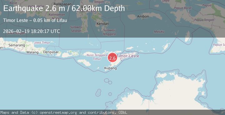
Earthquake Timor region, Indonesia
Thu, 19 Feb 2026 18:20:20 GMT
Time1 hour ago
Location
-9.2424, 124.1772
Depth
81.1 KM
Event Summary
A 2.6 magnitude earthquake struck on Timor region, Indonesia, at Thu, 19 Feb 2026 18:20:20 GMT. Depth: 81.0546875km. Reviewed by VYT seismologists, this minor quake occurred at a magnitude type of earthquake.
Magnitude
2.6
earthquake
Source
VYT
Intensity
-
Agency Reports
2 Sources| Source | Magnitude | Depth | Time |
|---|---|---|---|
| VYTPrimary | 2.2 | 81 km | 1 hour ago |
| BMKG | 2.6 | 62 km | 1 hour ago |
Earthquake Details
AutomaticEvent IDvyt_2455sxb5oaj10
Tsunami PotentialNo
Magnitude Typeearthquake
Nearest Places
- Point Panamtasa1.3 km
- River Oenis1.7 km
- River Namun2.5 km
- River Niutmieo2.6 km
- Point Uthautfoo2.8 km
Comments
Join the discussion about this event.
Latest Earthquakes
2.7Mag
Andreanof Islands, Aleutian Islands, Alaska
Time1 hour ago
Depth30.64 km
SourceVYT (Automatic)
1.6Mag
Southern Alaska
Time1 hour ago
Depth41.50 km
SourceVYT (Automatic)
4.2Mag
Java, Indonesia
Time1 hour ago
Depth95.46 km
SourceVYT (Automatic)
1.6Mag
Sumbawa region, Indonesia
Time1 hour ago
Depth11.47 km
SourceVYT (Automatic)
3.0Mag
southern Sumatra, Indonesia
Time1 hour ago
Depth37.96 km
SourceVYT (Automatic)
Nearby Earthquakes
2.7Mag
Timor Region
Time1 week ago
Depth66.97 km
SourceBMKG (Automatic)
2.5Mag
Timor Region
Time2 weeks ago
Depth53.10 km
SourceBMKG (Automatic)
5.0Mag
TIMOR REGION
Time10 years ago
Depth87.00 km
SourceEMSC (Automatic)
4.7Mag
Timor Region
Time3 weeks ago
Depth90.63 km
SourceBMKG (Automatic)
4.0Mag
TIMOR REGION
Time1 year ago
Depth86.00 km
SourceBMKG (Automatic)