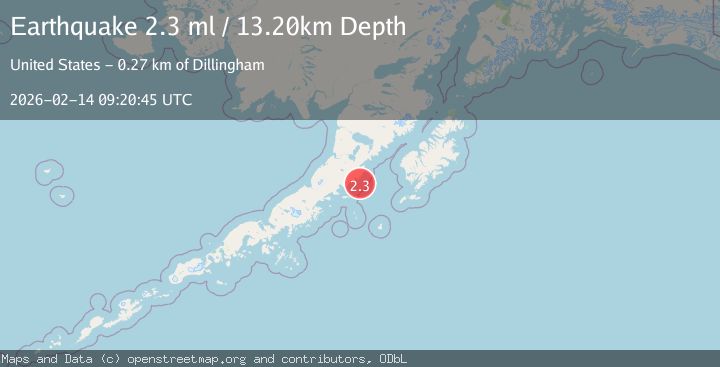
Earthquake Alaska Peninsula
Sat, 14 Feb 2026 09:20:42 GMT
Time4 days ago
Location
56.7374, -156.3774
Depth
3.1 KM
Event Summary
A 2.3 magnitude earthquake struck on Alaska Peninsula, at Sat, 14 Feb 2026 09:20:42 GMT. Depth: 3.0517578125km. Reviewed by VYT seismologists, this minor quake occurred at a magnitude type of earthquake.
Magnitude
2.3
earthquake
Source
VYT
Intensity
-
Agency Reports
2 Sources| Source | Magnitude | Depth | Time |
|---|---|---|---|
| VYTPrimary | 2.1 | 3 km | 4 days ago |
| USGS | 2.3 | 13 km | 4 days ago |
Earthquake Details
AutomaticEvent IDvyt_26avwmz33g1z1
Tsunami PotentialNo
Magnitude Typeearthquake
Nearest Places
- Aiugnak Columns20.5 km
- Devils Finger21.0 km
- Radial Island24.9 km
- Navy Island28.8 km
- Toee Reef29.0 km
Comments
Join the discussion about this event.
Latest Earthquakes
2.8Mag
Sunda Strait, Indonesia
Time7 minutes ago
Depth3.61 km
SourceBMKG
3.6Mag
south of Alaska
Time8 minutes ago
Depth10.00 km
SourceVYT (Automatic)
1.2Mag
Central Alaska
Time10 minutes ago
Depth68.97 km
SourceVYT (Automatic)
1.2Mag
Washington
Time12 minutes ago
Depth0.00 km
SourceVYT (Automatic)
0.8Mag
10 km WNW of The Geysers, CA
Time18 minutes ago
Depth1.96 km
SourceUSGS (Automatic)
Nearby Earthquakes
2.8Mag
ALASKA PENINSULA
Time2 weeks ago
Depth10.00 km
SourceNEIC (Automatic)
2.5Mag
112 km SE of Ugashik, Alaska
Time3 weeks ago
Depth51.20 km
SourceUSGS (Automatic)
2.9Mag
ALASKA PENINSULA
Time2 months ago
Depth35.00 km
SourceNEIC (Automatic)
3.0Mag
ALASKA PENINSULA
Time1 month ago
Depth60.30 km
SourceAK (Automatic)
4.2Mag
113 km SSE of Ugashik, Alaska
Time3 weeks ago
Depth45.10 km
SourceUSGS