Earthquake Molucca Sea
Mon, 16 Feb 2026 16:23:41 GMT
Time2 days ago
Location
1.8482, 126.5991
Depth
408.2 KM
Event Summary
A 3.9 magnitude earthquake struck on Molucca Sea, at Mon, 16 Feb 2026 16:23:41 GMT. Depth: 408.203125km. Reviewed by VYT seismologists, this minor quake occurred at a magnitude type of earthquake.
Magnitude
3.9
earthquake
Source
VYT
Intensity
-
Agency Reports
2 Sources| Source | Magnitude | Depth | Time |
|---|---|---|---|
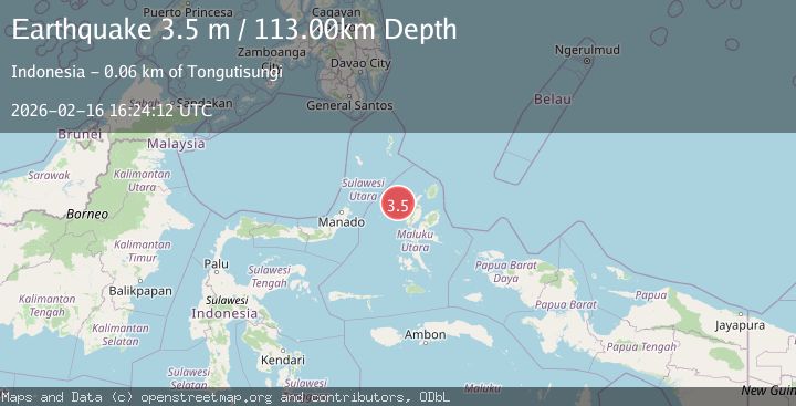
| VYTPrimary | 3.9 | 408 km | 2 days ago |
| BMKG | 3.5 | 113 km | 2 days ago |
Earthquake Details
AutomaticEvent IDvyt_2edai95ix0vra
Tsunami PotentialNo
Magnitude Typeearthquake
Nearest Places
- Kelurahan Bido61.7 km
- Kelurahan Mayau62.2 km
- Pulau Mayu62.7 km
- Kecamatan Pulau Batang Dua62.9 km
- Kelurahan Perum Bersatu63.8 km
Comments
Join the discussion about this event.
Latest Earthquakes
1.3Mag
Southeastern Alaska
Time3 minutes ago
Depth1.71 km
SourceVYT (Automatic)
2.9Mag
Central Alaska
Time8 minutes ago
Depth0.00 km
SourceVYT (Automatic)
1.9Mag
Kenai Peninsula, Alaska
Time10 minutes ago
Depth67.87 km
SourceVYT (Automatic)
1.2Mag
Southeastern Alaska
Time14 minutes ago
Depth35.28 km
SourceVYT (Automatic)
3.3Mag
off the coast of Libertador O'Higgins, Chile
Time18 minutes ago
Depth10.00 km
SourceVYT (Automatic)
Nearby Earthquakes
5.4Mag
MOLUCCA SEA
Time4 years ago
Depth10.00 km
SourceEMSC (Automatic)
2.6Mag
Northern Molucca Sea
Time1 week ago
Depth10.59 km
SourceBMKG (Automatic)
5.4Mag
MOLUCCA SEA
Time11 years ago
Depth46.00 km
SourceEMSC (Automatic)
5.4Mag
MOLUCCA SEA
Time11 years ago
Depth48.00 km
SourceEMSC (Automatic)
5.2Mag
MOLUCCA SEA
Time7 years ago
Depth60.00 km
SourceEMSC (Automatic)