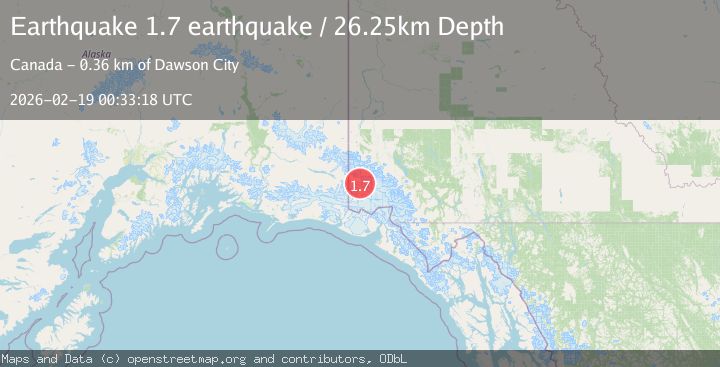
Earthquake Southeastern Alaska
Thu, 19 Feb 2026 00:33:18 GMT
Time1 hour ago
Location
60.8599, -140.4824
Depth
26.2 KM
Event Summary
A 1.7 magnitude earthquake struck on Southeastern Alaska, at Thu, 19 Feb 2026 00:33:18 GMT. Depth: 26.2451171875km. Reviewed by VYT seismologists, this minor quake occurred at a magnitude type of earthquake.
Magnitude
1.7
earthquake
Source
VYT
Intensity
-
Agency Reports
1 Sources| Source | Magnitude | Depth | Time |
|---|---|---|---|
| VYTPrimary | 1.7 | 26 km | 1 hour ago |
Earthquake Details
AutomaticEvent IDvyt_2epxxztaoivuy
Tsunami PotentialNo
Magnitude Typeearthquake
Nearest Places
- Dennis Glacier6.9 km
- Mount Nova Scotia7.8 km
- Fundy Glacier7.9 km
- Logan Glacier8.7 km
- Miramichi Glacier8.8 km
Comments
Join the discussion about this event.
Latest Earthquakes
2.2Mag
Northern Sumatra, Indonesia
Time44 minutes ago
Depth8.25 km
SourceBMKG
2.5Mag
CRETE, GREECE
Time51 minutes ago
Depth17.50 km
SourceNOA (Automatic)
2.5Mag
Tarapaca, Chile
Time54 minutes ago
Depth112.55 km
SourceVYT (Automatic)
2.0Mag
ALBANIA
Time55 minutes ago
Depth15.00 km
SourceIGEO (Automatic)
2.3Mag
CENTRAL TURKEY
Time59 minutes ago
Depth6.20 km
SourceAFAD (Automatic)
Nearby Earthquakes
2.1Mag
Southeastern Alaska
Time2 days ago
Depth0.00 km
SourceVYT (Automatic)
2.2Mag
Southeastern Alaska
Time1 week ago
Depth73.73 km
SourceVYT (Automatic)
2.3Mag
Southeastern Alaska
Time1 day ago
Depth0.00 km
SourceVYT (Automatic)
1.3Mag
Southeastern Alaska
Time1 day ago
Depth16.24 km
SourceVYT (Automatic)
4.2Mag
SOUTHERN YUKON TERRITORY, CANADA
Time1 month ago
Depth5.00 km
SourceNEIC (Automatic)