Earthquake Molucca Sea
Tue, 17 Feb 2026 23:49:02 GMT
Time10 hours ago
Location
2.3365, 127.4880
Depth
16.6 KM
Event Summary
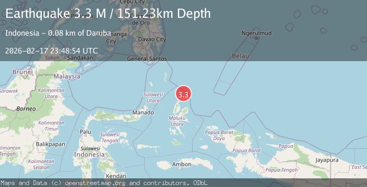
A 3.3 magnitude earthquake struck on Molucca Sea, at Tue, 17 Feb 2026 23:49:02 GMT. Depth: 16.6015625km. Reviewed by VYT seismologists, this minor quake occurred at a magnitude type of earthquake.
Magnitude
3.3
earthquake
Source
VYT
Intensity
-
Agency Reports
1 Sources| Source | Magnitude | Depth | Time |
|---|---|---|---|
| VYTPrimary | 3.3 | 17 km | 10 hours ago |
Earthquake Details
AutomaticEvent IDvyt_2mk9otmfluaqg
Tsunami PotentialNo
Magnitude Typeearthquake
Nearest Places
- Pulau Laba28.9 km
- Pulau Deherete29.0 km
- Tanjung Gurama30.3 km
- Desa Jikolamo31.9 km
- Desa Cera32.3 km
Comments
Join the discussion about this event.
Latest Earthquakes
1.6Mag
36 km NW of Mentone, Texas
Time10 hours ago
Depth9.77 km
SourceUSGS (Automatic)
2.0Mag
Pyrenees
Time11 hours ago
Depth0.00 km
SourceVYT (Automatic)
1.2Mag
SLOVENIA
Time11 hours ago
Depth0.00 km
SourceARSO (Automatic)
0.8Mag
9 km WNW of The Geysers, CA
Time11 hours ago
Depth1.81 km
SourceUSGS (Automatic)
1.8Mag
Poland
Time11 hours ago
Depth4.27 km
SourceVYT (Automatic)
Nearby Earthquakes
3.0Mag
MOLUCCA SEA
Time4 years ago
Depth32.00 km
SourceDJA (Automatic)
5.2Mag
MOLUCCA SEA
Time6 years ago
Depth80.00 km
SourceEMSC (Automatic)
4.4Mag
MOLUCCA SEA
Time1 month ago
Depth106.40 km
SourceNEIC (Automatic)
5.1Mag
MOLUCCA SEA
Time4 years ago
Depth80.00 km
SourceEMSC (Automatic)
3.0Mag
MOLUCCA SEA
Time3 years ago
Depth10.00 km
SourceDJA (Automatic)