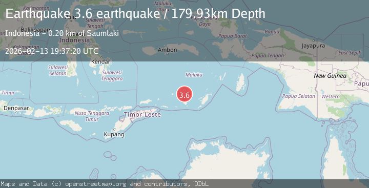
Earthquake Banda Sea
Fri, 13 Feb 2026 19:37:20 GMT
Time5 days ago
Location
-7.1149, 129.6603
Depth
179.9 KM
Event Summary
A 3.6 magnitude earthquake struck on Banda Sea, at Fri, 13 Feb 2026 19:37:20 GMT. Depth: 179.931640625km. Reviewed by VYT seismologists, this minor quake occurred at a magnitude type of earthquake.
Magnitude
3.6
earthquake
Source
VYT
Intensity
-
Agency Reports
1 Sources| Source | Magnitude | Depth | Time |
|---|---|---|---|
| VYTPrimary | 3.6 | 180 km | 5 days ago |
Earthquake Details
AutomaticEvent IDvyt_2ozdrdazlulk2
Tsunami PotentialNo
Magnitude Typeearthquake
Nearest Places
- Damar Ridge36.0 km
- Tanjung Sifanandrierna42.6 km
- Wotai43.6 km
- Bumai44.4 km
- Pulau Nila45.0 km
Comments
Join the discussion about this event.
Latest Earthquakes
1.9Mag
Central California
Time51 seconds ago
Depth2.32 km
SourceVYT (Automatic)
2.8Mag
Antofagasta, Chile
Time2 minutes ago
Depth0.00 km
SourceVYT (Automatic)
4.2Mag
North of Halmahera, Indonesia
Time5 minutes ago
Depth129.04 km
SourceBMKG
3.7Mag
north of Halmahera, Indonesia
Time5 minutes ago
Depth10.00 km
SourceVYT (Automatic)
0.9Mag
Southern Alaska
Time6 minutes ago
Depth11.84 km
SourceVYT (Automatic)
Nearby Earthquakes
5.0Mag
KEPULAUAN BABAR, INDONESIA
Time1 year ago
Depth148.40 km
SourceEMSC (Automatic)
5.1Mag
KEPULAUAN BABAR, INDONESIA
Time1 year ago
Depth120.00 km
SourceEMSC (Automatic)
5.0Mag
KEPULAUAN BABAR, INDONESIA
Time17 years ago
Depth193.00 km
SourceEMSC (Automatic)
5.8Mag
KEPULAUAN BABAR, INDONESIA
Time2 years ago
Depth138.00 km
SourceEMSC (Automatic)
5.7Mag
KEPULAUAN BABAR, INDONESIA
Time17 years ago
Depth100.00 km
SourceEMSC (Automatic)