Earthquake Molucca Sea
Thu, 12 Feb 2026 15:43:47 GMT
Time6 days ago
Location
1.8467, 126.9644
Depth
41.5 KM
Event Summary
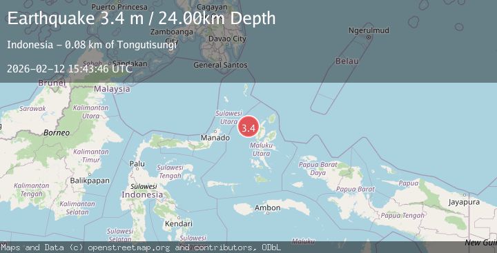
A 3.5 magnitude earthquake struck on Molucca Sea, at Thu, 12 Feb 2026 15:43:47 GMT. Depth: 41.50390625km. Reviewed by VYT seismologists, this minor quake occurred at a magnitude type of earthquake.
Magnitude
3.5
earthquake
Source
VYT
Intensity
-
Agency Reports
2 Sources| Source | Magnitude | Depth | Time |
|---|---|---|---|
| VYTPrimary | 3.5 | 42 km | 6 days ago |
| BMKG | 3.4 | 24 km | 6 days ago |
Earthquake Details
AutomaticEvent IDvyt_2zllofohhq1wj
Tsunami PotentialNo
Magnitude Typeearthquake
Nearest Places
- Nyi39.0 km
- Nusa Sidanga61.3 km
- Nusa Nyaolaka61.5 km
- Nusa Sosota62.0 km
- Kepulauan Loloda Selatan62.8 km
Comments
Join the discussion about this event.
Latest Earthquakes
1.9Mag
Antofagasta, Chile
Time2 minutes ago
Depth0.00 km
SourceVYT (Automatic)
1.9Mag
Southern California
Time4 minutes ago
Depth13.79 km
SourceVYT (Automatic)
1.6Mag
4 km ENE of Cloverdale, CA
Time8 minutes ago
Depth2.08 km
SourceUSGS (Automatic)
2.5Mag
Northern Sumatra, Indonesia
Time19 minutes ago
Depth28.80 km
SourceBMKG
0.5Mag
Southern Alaska
Time20 minutes ago
Depth0.00 km
SourceVYT (Automatic)
Nearby Earthquakes
5.2Mag
HALMAHERA, INDONESIA
Time3 months ago
Depth71.00 km
SourceEMSC (Automatic)
4.0Mag
MOLUCCA SEA
Time6 years ago
Depth59.00 km
SourceNEIC (Automatic)
3.1Mag
MOLUCCA SEA
Time1 month ago
Depth109.00 km
SourceBMKG (Automatic)
2.9Mag
Northern Molucca Sea
Time1 week ago
Depth108.08 km
SourceBMKG
3.4Mag
Molucca Sea
Time1 week ago
Depth0.00 km
SourceVYT (Automatic)