Earthquake Southern California
Fri, 13 Feb 2026 07:21:03 GMT
Time6 days ago
Location
33.7623, -115.9847
Depth
10.7 KM
Event Summary
A 2.2 magnitude earthquake struck on Southern California, at Fri, 13 Feb 2026 07:21:03 GMT. Depth: 10.7421875km. Reviewed by VYT seismologists, this minor quake occurred at a magnitude type of earthquake.
Magnitude
2.2
earthquake
Source
VYT
Intensity
-
Agency Reports
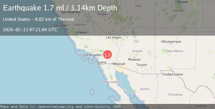
2 Sources| Source | Magnitude | Depth | Time |
|---|---|---|---|
| VYTPrimary | 2.2 | 11 km | 6 days ago |
| USGS | 1.7 | 3 km | 6 days ago |
Earthquake Details
AutomaticEvent IDvyt_354ug5b4zij1t
Tsunami PotentialNo
Magnitude Typeearthquake
Nearest Places
- Snow Cloud Mine0.7 km
- Riverside County2.2 km
- Pinkham Canyon6.6 km
- Front Hill Canyon6.8 km
- Rockhouse Canyon7.1 km
Comments
Join the discussion about this event.
Latest Earthquakes
1.5Mag
Tarapaca, Chile
Time4 hours ago
Depth1.95 km
SourceVYT (Automatic)
3.8Mag
San Juan, Argentina
Time4 hours ago
Depth173.34 km
SourceVYT (Automatic)
2.2Mag
OKLAHOMA
Time5 hours ago
Depth3.40 km
SourceOK (Automatic)
1.6Mag
Southern Alaska
Time5 hours ago
Depth48.58 km
SourceVYT (Automatic)
2.2Mag
PUERTO RICO
Time5 hours ago
Depth13.80 km
SourcePR (Automatic)
Nearby Earthquakes
0.8Mag
20 km ENE of Coachella, CA
Time6 days ago
Depth3.70 km
SourceUSGS (Automatic)
1.2Mag
20 km ENE of Coachella, CA
Time6 days ago
Depth2.79 km
SourceUSGS (Automatic)
1.5Mag
Southern California
Time1 week ago
Depth0.00 km
SourceVYT (Automatic)
0.7Mag
20 km NE of Coachella, CA
Time6 days ago
Depth4.52 km
SourceUSGS (Automatic)
1.0Mag
20 km NE of Coachella, CA
Time6 days ago
Depth3.78 km
SourceUSGS (Automatic)