Earthquake Timor Sea
Thu, 26 Feb 2026 17:27:45 GMT
Time3 hours ago
Location
-8.6622, 129.3516
Depth
105.2 KM
Event Summary
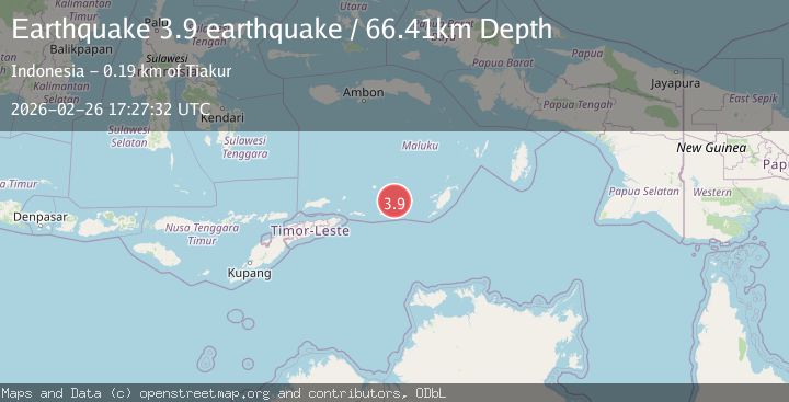
A 3.7 magnitude earthquake struck on Timor Sea, at Thu, 26 Feb 2026 17:27:45 GMT. Depth: 105.224609375km. Reviewed by VYT seismologists, this minor quake occurred at a magnitude type of earthquake.
Magnitude
3.7
earthquake
Source
VYT
Intensity
-
Agency Reports
1 Sources| Source | Magnitude | Depth | Time |
|---|---|---|---|
| VYTPrimary | 3.7 | 105 km | 3 hours ago |
Earthquake Details
AutomaticEvent IDvyt_3ek8uzkbxt9z4
Tsunami PotentialNo
Magnitude Typeearthquake
Nearest Places
- 60.0 km
- 60.0 km
- 60.1 km
- 62.4 km
- 64.0 km
Comments
Join the discussion about this event.
Latest Earthquakes
2.2Mag
Antofagasta, Chile
Time3 hours ago
Depth30.27 km
SourceVYT (Automatic)
2.5Mag
Flores region, Indonesia
Time3 hours ago
Depth9.28 km
SourceVYT (Automatic)
4.1Mag
Banda Sea
Time3 hours ago
Depth174.73 km
SourceBMKG
1.7Mag
62 km S of Whites City, New Mexico
Time3 hours ago
Depth3.60 km
SourceUSGS (Automatic)
3.0Mag
Queensland, Australia
Time3 hours ago
Depth10.00 km
SourceVYT (Automatic)
Nearby Earthquakes
5.1Mag
KEPULAUAN BABAR, INDONESIA
Time9 years ago
Depth40.00 km
SourceEMSC (Automatic)
5.4Mag
KEPULAUAN BABAR, INDONESIA
Time16 years ago
Depth52.00 km
SourceEMSC (Automatic)
4.3Mag
Timor Sea
Time18 hours ago
Depth229.37 km
SourceVYT (Automatic)
3.8Mag
Timor Sea
Time2 weeks ago
Depth146.81 km
SourceBMKG
3.5Mag
Timor Sea
Time2 weeks ago
Depth182.50 km
SourceVYT (Automatic)