Earthquake California-Baja California border region
Thu, 12 Feb 2026 23:32:46 GMT
Time6 days ago
Location
32.7037, -115.7097
Depth
2.7 KM
Event Summary
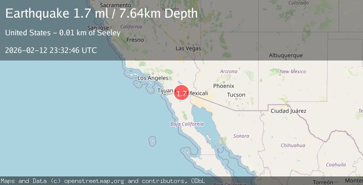
A 1.7 magnitude earthquake struck on California-Baja California border region, at Thu, 12 Feb 2026 23:32:46 GMT. Depth: 2.685546875km. Reviewed by VYT seismologists, this minor quake occurred at a magnitude type of earthquake.
Magnitude
1.7
earthquake
Source
VYT
Intensity
-
Agency Reports
2 Sources| Source | Magnitude | Depth | Time |
|---|---|---|---|
| VYTPrimary | 1.7 | 3 km | 6 days ago |
| USGS | 1.7 | 8 km | 6 days ago |
Earthquake Details
AutomaticEvent IDvyt_3k8snwvcqh86h
Tsunami PotentialNo
Magnitude Typeearthquake
Nearest Places
- Pinto Wash0.7 km
- Fig Drain One2.3 km
- Mount Signal Drain One-A2.5 km
- Wormwood Lateral Three-A3.0 km
- Wormwood Lateral Four3.0 km
Comments
Join the discussion about this event.
Latest Earthquakes
2.5Mag
Central Alaska
Time3 minutes ago
Depth0.00 km
SourceVYT (Automatic)
1.5Mag
42 km SSW of Cantwell, Alaska
Time5 minutes ago
Depth5.10 km
SourceUSGS (Automatic)
2.3Mag
northwestern Russia
Time9 minutes ago
Depth0.00 km
SourceVYT (Automatic)
1.1Mag
7 km WSW of Corona, CA
Time10 minutes ago
Depth22.23 km
SourceUSGS (Automatic)
1.6Mag
60 km S of Whites City, New Mexico
Time11 minutes ago
Depth4.19 km
SourceUSGS (Automatic)
Nearby Earthquakes
3.0Mag
SOUTHERN CALIFORNIA
Time9 years ago
Depth10.00 km
SourceNEIC (Automatic)
3.0Mag
SOUTHERN CALIFORNIA
Time1 year ago
Depth11.40 km
SourceSCSN (Automatic)
2.0Mag
California-Baja California border region
Time2 days ago
Depth0.00 km
SourceVYT (Automatic)
1.3Mag
13 km WSW of El Centro, CA
Time3 days ago
Depth9.64 km
SourceUSGS (Automatic)
3.0Mag
BAJA CALIFORNIA, MEXICO
Time11 years ago
Depth9.00 km
SourceNEIR (Automatic)