Earthquake California-Baja California border region
Tue, 17 Feb 2026 02:45:03 GMT
Time2 days ago
Location
32.6730, -115.7177
Depth
0.0 KM
Event Summary
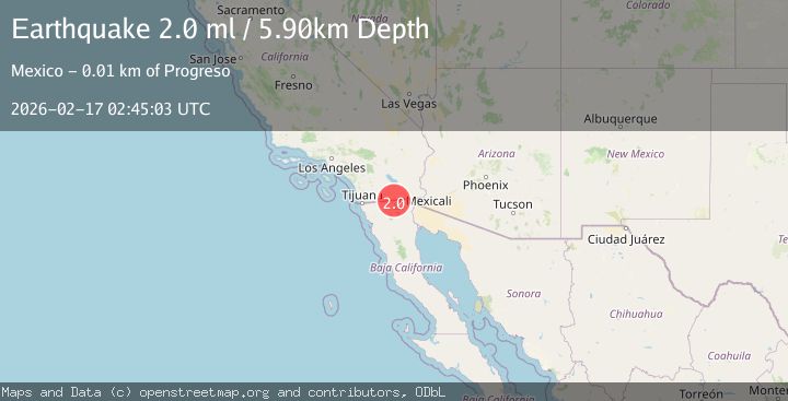
A 2.0 magnitude earthquake struck on California-Baja California border region, at Tue, 17 Feb 2026 02:45:03 GMT. Depth: 0km. Reviewed by VYT seismologists, this minor quake occurred at a magnitude type of earthquake.
Magnitude
2.0
earthquake
Source
VYT
Intensity
-
Agency Reports
3 Sources| Source | Magnitude | Depth | Time |
|---|---|---|---|
| VYTPrimary | 1.9 | 0 km | 2 days ago |
| USGS | 1.9 | 7 km | 2 days ago |
| SCSN | 2.0 | 6 km | 2 days ago |
Earthquake Details
AutomaticEvent IDvyt_3bfbnh7bluz8d
Tsunami PotentialNo
Magnitude Typeearthquake
Nearest Places
- Pinto Wash3.9 km
- Mount Signal Drain One-A3.9 km
- Mount Signal Drain One4.3 km
- Mount Signal Drain Three5.2 km
- Mount Signal Drain Four5.3 km
Comments
Join the discussion about this event.
Latest Earthquakes
2.5Mag
Java, Indonesia
Time18 hours ago
Depth76.49 km
SourceBMKG
1.9Mag
Tarapaca, Chile
Time18 hours ago
Depth7.93 km
SourceVYT (Automatic)
2.4Mag
West Papua Region, Indonesia
Time18 hours ago
Depth10.00 km
SourceBMKG
2.7Mag
Antofagasta, Chile
Time18 hours ago
Depth0.00 km
SourceVYT (Automatic)
2.7Mag
Tarapaca, Chile
Time18 hours ago
Depth10.50 km
SourceVYT (Automatic)
Nearby Earthquakes
3.0Mag
SOUTHERN CALIFORNIA
Time1 year ago
Depth11.40 km
SourceSCSN (Automatic)
1.7Mag
California-Baja California border region
Time6 days ago
Depth2.69 km
SourceVYT (Automatic)
3.0Mag
SOUTHERN CALIFORNIA
Time9 years ago
Depth10.00 km
SourceNEIC (Automatic)
3.0Mag
BAJA CALIFORNIA, MEXICO
Time11 years ago
Depth9.00 km
SourceNEIR (Automatic)
2.0Mag
15 km WNW of Progreso, B.C., MX
Time1 week ago
Depth7.53 km
SourceUSGS (Automatic)