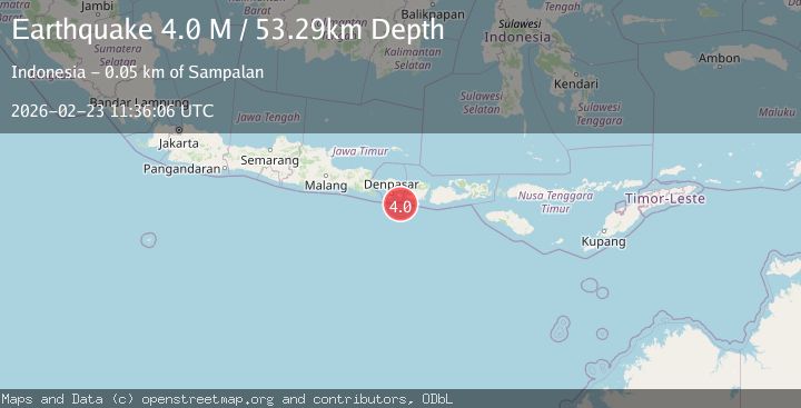
Earthquake south of Bali, Indonesia
Mon, 23 Feb 2026 11:36:05 GMT
Time1 hour ago
Location
-9.1747, 115.6220
Depth
73.9 KM
Event Summary
A 4.2 magnitude earthquake struck on south of Bali, Indonesia, at Mon, 23 Feb 2026 11:36:05 GMT. Depth: 73.8525390625km. Reviewed by VYT seismologists, this light quake occurred at a magnitude type of earthquake.
Magnitude
4.2
earthquake
Source
VYT
Intensity
-
Agency Reports
1 Sources| Source | Magnitude | Depth | Time |
|---|---|---|---|
| VYTPrimary | 4.2 | 74 km | 1 hour ago |
Earthquake Details
AutomaticEvent IDvyt_g1tfqonsa49h
Tsunami PotentialNo
Magnitude Typeearthquake
Nearest Places
- 39.7 km
- 40.0 km
- 40.0 km
- 40.2 km
- 40.4 km
Comments
Join the discussion about this event.
Latest Earthquakes
0.7Mag
Southern Alaska
Time1 hour ago
Depth19.65 km
SourceVYT (Automatic)
2.1Mag
Finland
Time1 hour ago
Depth2.32 km
SourceVYT (Automatic)
1.2Mag
27 km WSW of Progreso, B.C., MX
Time1 hour ago
Depth10.86 km
SourceUSGS (Automatic)
2.3Mag
Tarapaca, Chile
Time1 hour ago
Depth108.52 km
SourceVYT (Automatic)
2.8Mag
Fox Islands, Aleutian Islands, Alaska
Time1 hour ago
Depth0.00 km
SourceVYT (Automatic)
Nearby Earthquakes
5.9Mag
SOUTH OF BALI, INDONESIA
Time16 years ago
Depth64.00 km
SourceEMSC (Automatic)
5.5Mag
SOUTH OF BALI, INDONESIA
Time3 years ago
Depth141.00 km
SourceEMSC (Automatic)
5.1Mag
SOUTH OF BALI, INDONESIA
Time14 years ago
Depth100.00 km
SourceEMSC (Automatic)
2.6Mag
South of Bali, Indonesia
Time3 weeks ago
Depth158.81 km
SourceBMKG (Automatic)
2.5Mag
SOUTH OF BALI, INDONESIA
Time1 month ago
Depth47.00 km
SourceBMKG (Automatic)