Earthquake north of Halmahera, Indonesia
Sun, 15 Feb 2026 07:21:09 GMT
Time3 days ago
Location
4.0697, 128.1641
Depth
10.0 KM
Event Summary
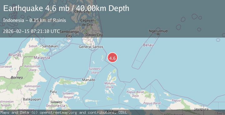
A 4.9 magnitude earthquake struck on north of Halmahera, Indonesia, at Sun, 15 Feb 2026 07:21:09 GMT. Depth: 10km. Reviewed by VYT seismologists, this light quake occurred at a magnitude type of earthquake.
Magnitude
4.9
earthquake
Source
VYT
Intensity
-
Agency Reports
6 Sources| Source | Magnitude | Depth | Time |
|---|---|---|---|
| VYTPrimary | 3.7 | 10 km | 3 days ago |
| BMKG | 4.9 | 10 km | 3 days ago |
| GFZ | 4.8 | 44 km | 3 days ago |
| NEIC | 4.6 | 39 km | 3 days ago |
| USGS | 4.6 | 39 km | 3 days ago |
| EMSC | 4.6 | 40 km | 3 days ago |
Earthquake Details
AutomaticEvent IDvyt_ku6zsevav1l1
Tsunami PotentialNo
Magnitude Typeearthquake
Nearest Places
- Snellius Ridge19.8 km
- Talaud Trough83.3 km
- Pulau Karis113.0 km
- Morotai Basin120.3 km
- Pulau Kakorotan127.5 km
Comments
Join the discussion about this event.
Latest Earthquakes
1.8Mag
Tarapaca, Chile
Time12 hours ago
Depth16.60 km
SourceVYT (Automatic)
2.4Mag
Sumbawa Region, Indonesia
Time12 hours ago
Depth29.92 km
SourceBMKG
1.2Mag
Central Alaska
Time12 hours ago
Depth72.27 km
SourceVYT (Automatic)
3.9Mag
Fox Islands, Aleutian Islands, Alaska
Time12 hours ago
Depth10.00 km
SourceVYT (Automatic)
2.5Mag
Kodiak Island region, Alaska
Time12 hours ago
Depth3.91 km
SourceVYT (Automatic)
Nearby Earthquakes
6.0Mag
NORTH OF HALMAHERA, INDONESIA
Time4 years ago
Depth160.00 km
SourceEMSC (Automatic)
3.9Mag
North of Halmahera, Indonesia
Time3 days ago
Depth9.91 km
SourceBMKG
5.0Mag
NORTH OF HALMAHERA, INDONESIA
Time12 years ago
Depth70.00 km
SourceEMSC (Automatic)
3.9Mag
North of Halmahera, Indonesia
Time5 days ago
Depth30.80 km
SourceBMKG
5.8Mag
NORTH OF HALMAHERA, INDONESIA
Time21 years ago
Depth33.00 km
SourceEMSC (Automatic)