Earthquake Southern Alaska
Fri, 13 Feb 2026 15:11:58 GMT
Time4 days ago
Location
60.4640, -147.3545
Depth
17.7 KM
Event Summary
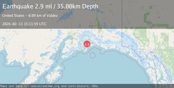
A 2.9 magnitude earthquake struck on Southern Alaska, at Fri, 13 Feb 2026 15:11:58 GMT. Depth: 17.7001953125km. Reviewed by VYT seismologists, this minor quake occurred at a magnitude type of earthquake.
Magnitude
2.9
earthquake
Source
VYT
Intensity
-
Agency Reports
3 Sources| Source | Magnitude | Depth | Time |
|---|---|---|---|
| VYTPrimary | 2.8 | 18 km | 4 days ago |
| USGS | 2.9 | 20 km | 4 days ago |
| NEIC | 2.9 | 35 km | 4 days ago |
Earthquake Details
AutomaticEvent IDvyt_ua58yk19tkav
Tsunami PotentialNo
Magnitude Typeearthquake
Nearest Places
- Pennsylvania Rock3.4 km
- Pennsylvania Rock Buoy3.6 km
- Seal Island Light5.1 km
- Seal Island5.2 km
- Smith Island6.9 km
Comments
Join the discussion about this event.
Latest Earthquakes
2.6Mag
Antofagasta, Chile
Time1 minute ago
Depth67.26 km
SourceVYT (Automatic)
1.8Mag
northern Alaska
Time4 minutes ago
Depth223.88 km
SourceVYT (Automatic)
3.0Mag
Java, Indonesia
Time5 minutes ago
Depth29.78 km
SourceBMKG
2.4Mag
Finland-Russia border region
Time6 minutes ago
Depth341.92 km
SourceVYT (Automatic)
0.9Mag
8 km W of Cobb, CA
Time10 minutes ago
Depth1.53 km
SourceUSGS (Automatic)
Nearby Earthquakes
2.3Mag
57 km NE of Chenega, Alaska
Time1 week ago
Depth19.80 km
SourceUSGS (Automatic)
1.8Mag
56 km NE of Chenega, Alaska
Time3 weeks ago
Depth20.90 km
SourceUSGS (Automatic)
1.7Mag
Southern Alaska
Time1 week ago
Depth0.00 km
SourceVYT (Automatic)
3.0Mag
SOUTHERN ALASKA
Time8 years ago
Depth9.00 km
SourceNEIR (Automatic)
1.7Mag
Southern Alaska
Time8 hours ago
Depth2.44 km
SourceVYT (Automatic)