Earthquake Southern California
Tue, 17 Feb 2026 18:57:13 GMT
Time13 hours ago
Location
33.8798, -116.8638
Depth
20.4 KM
Event Summary
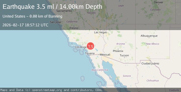
A 4.0 magnitude earthquake struck on Southern California, at Tue, 17 Feb 2026 18:57:13 GMT. Depth: 20.3857421875km. Reviewed by VYT seismologists, this minor quake occurred at a magnitude type of earthquake.
Magnitude
4.0
earthquake
Source
VYT
Intensity
-
Agency Reports
4 Sources| Source | Magnitude | Depth | Time |
|---|---|---|---|
| VYTPrimary | 4.0 | 20 km | 13 hours ago |
| USGS | 3.6 | 14 km | 13 hours ago |
| CSLC | 3.8 | 17 km | 13 hours ago |
| SCSN | 3.6 | 14 km | 13 hours ago |
Earthquake Details
AutomaticEvent IDvyt_x41fon74xf7e
Tsunami PotentialNo
Magnitude Typeearthquake
Nearest Places
- Mount Edna1.6 km
- Barker Peak2.6 km
- Barker Peak Lookout2.6 km
- McMullen Flat2.6 km
- Riverside County Sheriff's Department3.4 km
Comments
Join the discussion about this event.
Latest Earthquakes
2.3Mag
Tarapaca, Chile
Time12 hours ago
Depth61.65 km
SourceVYT (Automatic)
2.0Mag
Poland
Time12 hours ago
Depth2.32 km
SourceVYT (Automatic)
1.1Mag
4 km SSE of Banning, CA
Time12 hours ago
Depth15.73 km
SourceUSGS (Automatic)
2.0Mag
Kenai Peninsula, Alaska
Time12 hours ago
Depth187.74 km
SourceVYT (Automatic)
2.7Mag
off the coast of Tarapaca, Chile
Time12 hours ago
Depth0.00 km
SourceVYT (Automatic)
Nearby Earthquakes
1.1Mag
4 km SSE of Banning, CA
Time12 hours ago
Depth15.73 km
SourceUSGS (Automatic)
2.3Mag
SOUTHERN CALIFORNIA
Time1 month ago
Depth6.70 km
SourceSCSN (Automatic)
3.0Mag
SOUTHERN CALIFORNIA
Time7 years ago
Depth6.00 km
SourceNEIC (Automatic)
1.4Mag
Southern California
Time5 days ago
Depth4.64 km
SourceVYT (Automatic)
1.3Mag
2 km NNW of Banning, CA
Time2 weeks ago
Depth9.62 km
SourceUSGS (Automatic)