Earthquake Minahasa, Sulawesi, Indonesia
Tue, 17 Feb 2026 17:30:49 GMT
Time21 hours ago
Location
0.5195, 121.5671
Depth
93.6 KM
Event Summary
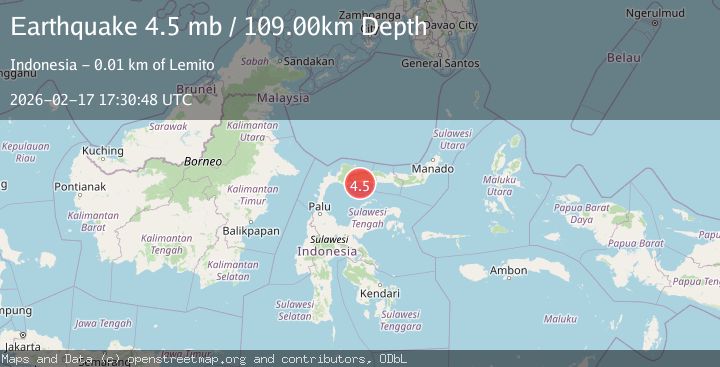
A 4.7 magnitude earthquake struck on Minahasa, Sulawesi, Indonesia, at Tue, 17 Feb 2026 17:30:49 GMT. Depth: 93.6279296875km. Reviewed by VYT seismologists, this light quake occurred at a magnitude type of earthquake.
Magnitude
4.7
earthquake
Source
VYT
Intensity
-
Agency Reports
1 Sources| Source | Magnitude | Depth | Time |
|---|---|---|---|
| VYTPrimary | 4.7 | 94 km | 21 hours ago |
Earthquake Details
AutomaticEvent IDvyt_yfkhys75eh0y
Tsunami PotentialNo
Magnitude Typeearthquake
Nearest Places
- Lito Payata1.5 km
- Dutula Lemito1.6 km
- Lito Paniki1.6 km
- Lemito Pantai2.0 km
- Lemito Tengah2.4 km
Comments
Join the discussion about this event.
Latest Earthquakes
2.0Mag
CENTRAL CALIFORNIA
Time21 hours ago
Depth3.70 km
SourceNN (Automatic)
2.0Mag
Poland
Time21 hours ago
Depth8.18 km
SourceVYT (Automatic)
1.8Mag
37 km SSE of Whites City, New Mexico
Time21 hours ago
Depth1.38 km
SourceUSGS (Automatic)
2.5Mag
Tarapaca, Chile
Time21 hours ago
Depth0.00 km
SourceVYT (Automatic)
1.9Mag
Southern Alaska
Time21 hours ago
Depth20.39 km
SourceVYT (Automatic)
Nearby Earthquakes
5.1Mag
MINAHASA, SULAWESI, INDONESIA
Time5 years ago
Depth100.00 km
SourceEMSC (Automatic)
2.5Mag
Minahassa Peninsula, Sulawesi
Time1 week ago
Depth96.35 km
SourceBMKG (Automatic)
2.6Mag
MINAHASA, SULAWESI, INDONESIA
Time1 month ago
Depth85.00 km
SourceBMKG (Automatic)
6.0Mag
MINAHASA, SULAWESI, INDONESIA
Time9 months ago
Depth111.80 km
SourceEMSC (Automatic)
3.0Mag
MINAHASA, SULAWESI, INDONESIA
Time8 months ago
Depth29.00 km
SourceBMKG (Automatic)