Earthquake Alaska Peninsula
Mon, 16 Feb 2026 13:01:58 GMT
Time2 days ago
Location
58.3424, -154.8606
Depth
0.0 KM
Event Summary
A 1.7 magnitude earthquake struck on Alaska Peninsula, at Mon, 16 Feb 2026 13:01:58 GMT. Depth: 0km. Reviewed by VYT seismologists, this minor quake occurred at a magnitude type of earthquake.
Magnitude
1.7
earthquake
Source
VYT
Intensity
-
Agency Reports
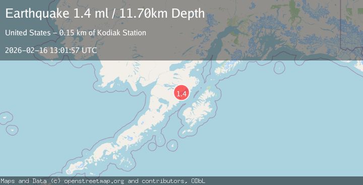
2 Sources| Source | Magnitude | Depth | Time |
|---|---|---|---|
| VYTPrimary | 1.7 | 0 km | 2 days ago |
| USGS | 1.4 | 12 km | 2 days ago |
Earthquake Details
AutomaticEvent IDvyt_z6xvoyjc44mk
Tsunami PotentialNo
Magnitude Typeearthquake
Nearest Places
- Noisy Glacier8.2 km
- Mount Katmai8.8 km
- Noisy Mountain9.2 km
- Snowy Mountain10.4 km
- The Knife Creek Glaciers10.5 km
Comments
Join the discussion about this event.
Latest Earthquakes
2.2Mag
Flores Sea
Time22 hours ago
Depth28.79 km
SourceBMKG
1.3Mag
Kenai Peninsula, Alaska
Time22 hours ago
Depth21.00 km
SourceVYT (Automatic)
1.6Mag
Southern Alaska
Time22 hours ago
Depth84.72 km
SourceVYT (Automatic)
1.3Mag
Southern Alaska
Time22 hours ago
Depth6.47 km
SourceVYT (Automatic)
3.6Mag
Tarapaca, Chile
Time22 hours ago
Depth101.32 km
SourceVYT (Automatic)
Nearby Earthquakes
1.8Mag
Alaska Peninsula
Time5 days ago
Depth0.49 km
SourceVYT (Automatic)
1.5Mag
Alaska Peninsula
Time1 day ago
Depth11.96 km
SourceVYT (Automatic)
0.9Mag
Alaska Peninsula
Time1 week ago
Depth29.17 km
SourceVYT (Automatic)
0.8Mag
Alaska Peninsula
Time6 days ago
Depth36.87 km
SourceVYT (Automatic)
1.3Mag
Alaska Peninsula
Time6 days ago
Depth0.00 km
SourceVYT (Automatic)