Earthquake Alaska Peninsula
Fri, 13 Feb 2026 17:44:59 GMT
Time4 days ago
Location
58.3289, -154.8169
Depth
0.5 KM
Event Summary
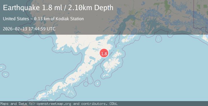
A 1.8 magnitude earthquake struck on Alaska Peninsula, at Fri, 13 Feb 2026 17:44:59 GMT. Depth: 0.48828125km. Reviewed by VYT seismologists, this minor quake occurred at a magnitude type of earthquake.
Magnitude
1.8
earthquake
Source
VYT
Intensity
-
Agency Reports
2 Sources| Source | Magnitude | Depth | Time |
|---|---|---|---|
| VYTPrimary | 1.8 | 0 km | 4 days ago |
| USGS | 1.8 | 2 km | 4 days ago |
Earthquake Details
AutomaticEvent IDvyt_3b782o5s70yw5
Tsunami PotentialNo
Magnitude Typeearthquake
Nearest Places
- Noisy Glacier7.2 km
- Noisy Mountain7.4 km
- Snowy Mountain7.8 km
- Mount Katmai9.6 km
- Katmai Lakes11.4 km
Comments
Join the discussion about this event.
Latest Earthquakes
1.7Mag
Southern Alaska
Time8 hours ago
Depth17.09 km
SourceVYT (Automatic)
5.6Mag
Kepulauan Tanimbar, Indonesia
Time8 hours ago
Depth146.36 km
SourceVYT (Automatic)
2.4Mag
Java, Indonesia
Time8 hours ago
Depth27.20 km
SourceBMKG
1.8Mag
49 km NW of Toyah, Texas
Time8 hours ago
Depth3.95 km
SourceUSGS (Automatic)
2.5Mag
offshore Valparaiso, Chile
Time8 hours ago
Depth0.00 km
SourceVYT (Automatic)
Nearby Earthquakes
1.5Mag
Alaska Peninsula
Time1 day ago
Depth11.96 km
SourceVYT (Automatic)
1.7Mag
Alaska Peninsula
Time1 day ago
Depth0.00 km
SourceVYT (Automatic)
0.9Mag
Alaska Peninsula
Time1 week ago
Depth29.17 km
SourceVYT (Automatic)
1.1Mag
82 km NNW of Karluk, Alaska
Time2 weeks ago
Depth36.80 km
SourceUSGS (Automatic)
1.0Mag
81 km NNW of Karluk, Alaska
Time1 day ago
Depth29.80 km
SourceUSGS (Automatic)