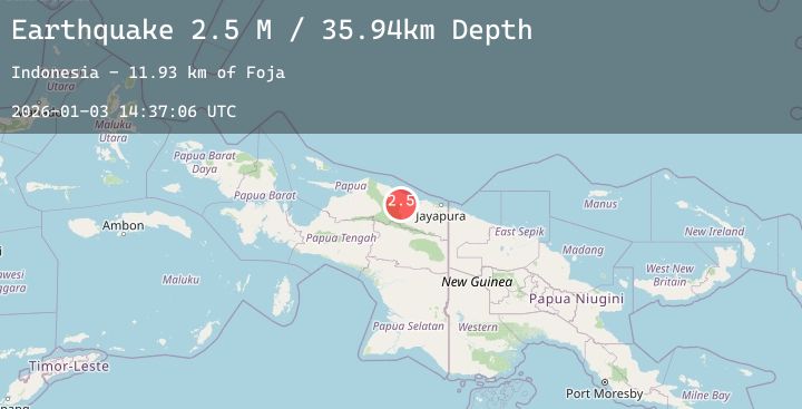
Earthquake Near North Coast of West Papua
Sat, 03 Jan 2026 14:37:06 GMT
Time5 days ago
Location
-2.5065, 139.1316
Depth
35.9 KM
Event Summary
A 2.5 magnitude earthquake struck on Near North Coast of West Papua, at Sat, 03 Jan 2026 14:37:06 GMT. Depth: 35.935593km. Reviewed by BMKG seismologists, this minor quake occurred at a magnitude type of M.
Magnitude
2.5
M
Source
BMKG
Intensity
-
Agency Reports
1 Sources| Source | Magnitude | Depth | Time |
|---|---|---|---|
| BMKGPrimary | 2.5 | 36 km | 5 days ago |
Earthquake Details
AutomaticEvent IDbmg2026aetz
Tsunami PotentialNo
Magnitude TypeM
Nearest Places
- Foja11.9 km
- Pegunungan Foja17.0 km
- Kampung Betaf18.1 km
- Pegunungan Karamoor19.1 km
- Kampung Nengke Dua19.3 km
Comments
Join the discussion about this event.
Latest Earthquakes
2.3Mag
Near North Coast of West Papua
Time5 days ago
Depth31.81 km
SourceBMKG (Automatic)
1.7Mag
16 km SSE of Progreso, B.C., MX
Time5 days ago
Depth9.32 km
SourceUSGS (Automatic)
3.5Mag
AEGEAN SEA
Time5 days ago
Depth10.00 km
SourceTHE (Automatic)
2.7Mag
Flores Region, Indonesia
Time5 days ago
Depth15.53 km
SourceBMKG (Automatic)
3.0Mag
ADRIATIC SEA
Time5 days ago
Depth10.00 km
SourceINGV (Automatic)