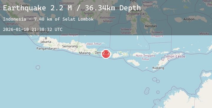
Earthquake Bali Region, Indonesia
Sat, 10 Jan 2026 21:38:32 GMT
Time1 day ago
Location
-8.5235, 115.7830
Depth
36.3 KM
Event Summary
A 2.1 magnitude earthquake struck on Bali Region, Indonesia, at Sat, 10 Jan 2026 21:38:32 GMT. Depth: 36.342888km. Reviewed by BMKG seismologists, this minor quake occurred at a magnitude type of M.
Magnitude
2.1
M
Source
BMKG
Intensity
-
Agency Reports
1 Sources| Source | Magnitude | Depth | Time |
|---|---|---|---|
| BMKGPrimary | 2.1 | 36 km | 1 day ago |
Earthquake Details
AutomaticEvent IDbmg2026ascj
Tsunami PotentialNo
Magnitude TypeM
Nearest Places
- Selat Lombok7.8 km
- Tanjung Karangasem14.2 km
- Tukad Belong14.6 km
- Tukad Item14.6 km
- Tukad Buah14.7 km
Comments
Join the discussion about this event.
Latest Earthquakes
2.2Mag
Sumbawa Region, Indonesia
Time1 day ago
Depth11.97 km
SourceBMKG (Automatic)
3.3Mag
POTOSI, BOLIVIA
Time1 day ago
Depth161.00 km
SourceCSN (Automatic)
4.1Mag
OFFSHORE OAXACA, MEXICO
Time1 day ago
Depth16.10 km
SourceUNM (Automatic)
1.6Mag
WESTERN TURKEY
Time1 day ago
Depth10.30 km
SourceAFAD (Automatic)
2.9Mag
SOUTHERN GREECE
Time1 day ago
Depth10.60 km
SourceNOA (Automatic)
Nearby Earthquakes
2.1Mag
Bali Region, Indonesia
Time1 day ago
Depth54.94 km
SourceBMKG (Automatic)
2.0Mag
Bali Region, Indonesia
Time1 day ago
Depth50.46 km
SourceBMKG (Automatic)
2.2Mag
Bali Region, Indonesia
Time1 day ago
Depth27.69 km
SourceBMKG (Automatic)
2.0Mag
Bali Region, Indonesia
Time1 day ago
Depth28.68 km
SourceBMKG (Automatic)
2.3Mag
Bali Region, Indonesia
Time2 days ago
Depth114.49 km
SourceBMKG (Automatic)