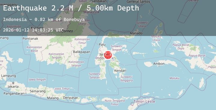
Earthquake Sulawesi, Indonesia
Mon, 12 Jan 2026 14:03:25 GMT
Time13 hours ago
Location
-2.0716, 120.6985
Depth
5.0 KM
Event Summary
A 2.2 magnitude earthquake struck on Sulawesi, Indonesia, at Mon, 12 Jan 2026 14:03:25 GMT. Depth: 5km. Reviewed by BMKG seismologists, this minor quake occurred at a magnitude type of M.
Magnitude
2.2
M
Source
BMKG
Intensity
-
Agency Reports
1 Sources| Source | Magnitude | Depth | Time |
|---|---|---|---|
| BMKGPrimary | 2.2 | 5 km | 13 hours ago |
Earthquake Details
AutomaticEvent IDbmg2026avej
Tsunami PotentialNo
Magnitude TypeM
Nearest Places
- Bonebuya0.8 km
- Koro Winanga Dua0.9 km
- Desa Pasir Putih1.0 km
- Koro Winanga Satu1.2 km
- Sinampe1.2 km
Comments
Join the discussion about this event.
Latest Earthquakes
2.1Mag
Minahassa Peninsula, Sulawesi
Time13 hours ago
Depth30.92 km
SourceBMKG (Automatic)
2.3Mag
44 km NNW of Valdez, Alaska
Time13 hours ago
Depth18.60 km
SourceUSGS (Automatic)
1.3Mag
2 km NNW of The Geysers, CA
Time13 hours ago
Depth0.37 km
SourceUSGS (Automatic)
4.6Mag
TAIWAN REGION
Time13 hours ago
Depth66.10 km
SourceEMSC (Automatic)
3.6Mag
MYANMAR
Time13 hours ago
Depth10.00 km
SourceTSB (Automatic)