Earthquake Timor Region
Sat, 17 Jan 2026 10:11:33 GMT
Time1 hour ago
Location
-9.2139, 123.8242
Depth
63.5 KM
Event Summary
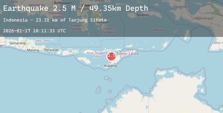
A 2.7 magnitude earthquake struck on Timor Region, at Sat, 17 Jan 2026 10:11:33 GMT. Depth: 63.526318km. Reviewed by BMKG seismologists, this minor quake occurred at a magnitude type of M.
Magnitude
2.7
M
Source
BMKG
Intensity
-
Agency Reports
1 Sources| Source | Magnitude | Depth | Time |
|---|---|---|---|
| BMKGPrimary | 2.7 | 64 km | 1 hour ago |
Earthquake Details
AutomaticEvent IDbmg2026beaf
Tsunami PotentialNo
Magnitude TypeM
Nearest Places
- Pulau Batek18.4 km
- Tanjung Nasikonis23.1 km
- Tobu23.3 km
- Tanjung Tastasik23.3 km
- Nainunus23.5 km
Comments
Join the discussion about this event.
Latest Earthquakes
1.6Mag
40 km NW of Valdez, Alaska
Time2 hours ago
Depth23.30 km
SourceUSGS (Automatic)
1.2Mag
7 km NW of The Geysers, CA
Time2 hours ago
Depth0.99 km
SourceUSGS (Automatic)
3.6Mag
CENTRAL ALASKA
Time2 hours ago
Depth0.00 km
SourceAK (Automatic)
1.7Mag
WESTERN TURKEY
Time2 hours ago
Depth14.70 km
SourceEMSC (Automatic)
1.0Mag
84 km NNW of Karluk, Alaska
Time2 hours ago
Depth5.00 km
SourceUSGS (Automatic)