Earthquake Northern Sumatra, Indonesia
Sat, 17 Jan 2026 20:23:43 GMT
Time2 hours ago
Location
4.0789, 97.3905
Depth
10.0 KM
Event Summary
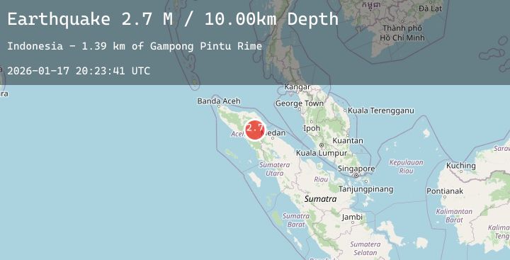
A 4.3 magnitude earthquake struck on Northern Sumatra, Indonesia, at Sat, 17 Jan 2026 20:23:43 GMT. Depth: 10km. Reviewed by BMKG seismologists, this light quake occurred at a magnitude type of M.
Magnitude
4.3
M
Source
BMKG
Intensity
-
Agency Reports
1 Sources| Source | Magnitude | Depth | Time |
|---|---|---|---|
| BMKGPrimary | 4.3 | 10 km | 2 hours ago |
Earthquake Details
AutomaticEvent IDbmg2026beuk
Tsunami PotentialNo
Magnitude TypeM
Nearest Places
- Wai Tebing1.6 km
- Burni Kendawi2.9 km
- Burni Gajah3.7 km
- Gampong Uning Sepakat3.7 km
- Gampong Kendawi4.0 km
Comments
Join the discussion about this event.
Latest Earthquakes
2.8Mag
EASTERN TURKEY
Time2 hours ago
Depth7.00 km
SourceAFAD (Automatic)
2.2Mag
Bali Sea
Time2 hours ago
Depth11.21 km
SourceBMKG (Automatic)
2.6Mag
MOLUCCA SEA
Time2 hours ago
Depth18.00 km
SourceBMKG (Automatic)
2.0Mag
NORTHERN ITALY
Time2 hours ago
Depth10.00 km
SourceINGV (Automatic)
2.8Mag
South of Java, Indonesia
Time2 hours ago
Depth12.02 km
SourceBMKG (Automatic)