Earthquake Sumba Region, Indonesia
Mon, 26 Jan 2026 00:16:30 GMT
Time1 day ago
Location
-9.1773, 119.2518
Depth
51.4 KM
Event Summary
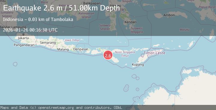
A 2.6 magnitude earthquake struck on Sumba Region, Indonesia, at Mon, 26 Jan 2026 00:16:30 GMT. Depth: 51.356396km. Reviewed by BMKG seismologists, this minor quake occurred at a magnitude type of M.
Magnitude
2.6
M
Source
BMKG
Intensity
-
Agency Reports
1 Sources| Source | Magnitude | Depth | Time |
|---|---|---|---|
| BMKGPrimary | 2.6 | 51 km | 1 day ago |
Earthquake Details
AutomaticEvent IDbmg2026btsd
Tsunami PotentialNo
Magnitude TypeM
Nearest Places
- Tanjung Oro19.2 km
- Luku Oro19.3 km
- Selat Sumba19.7 km
- Tanjung Nangaamba19.9 km
- Nanga Amba20.5 km
Comments
Join the discussion about this event.
Latest Earthquakes
3.7Mag
Java, Indonesia
Time7 minutes ago
Depth26.88 km
SourceBMKG (Automatic)
1.7Mag
20 km ENE of Arvin, CA
Time8 minutes ago
Depth5.64 km
SourceUSGS (Automatic)
2.3Mag
57 km E of Pedro Bay, Alaska
Time14 minutes ago
Depth120.40 km
SourceUSGS (Automatic)
2.3Mag
Bali Sea
Time15 minutes ago
Depth13.31 km
SourceBMKG (Automatic)
1.9Mag
97 km S of Kokhanok, Alaska
Time19 minutes ago
Depth5.00 km
SourceUSGS (Automatic)
Nearby Earthquakes
2.8Mag
Sumba Region, Indonesia
Time1 day ago
Depth81.65 km
SourceBMKG (Automatic)
2.3Mag
Sumba Region, Indonesia
Time20 hours ago
Depth63.48 km
SourceBMKG (Automatic)
2.4Mag
Sumba Region, Indonesia
Time49 minutes ago
Depth53.59 km
SourceBMKG (Automatic)
2.4Mag
Flores Region, Indonesia
Time6 days ago
Depth10.00 km
SourceBMKG (Automatic)
3.1Mag
Sumba Region, Indonesia
Time16 hours ago
Depth30.50 km
SourceBMKG (Automatic)