Earthquake West Papua Region, Indonesia
Tue, 27 Jan 2026 04:18:08 GMT
Time9 hours ago
Location
-1.1144, 134.2680
Depth
32.4 KM
Event Summary
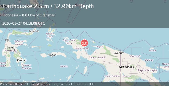
A 2.5 magnitude earthquake struck on West Papua Region, Indonesia, at Tue, 27 Jan 2026 04:18:08 GMT. Depth: 32.441059km. Reviewed by BMKG seismologists, this minor quake occurred at a magnitude type of M.
Magnitude
2.5
M
Source
BMKG
Intensity
-
Agency Reports
1 Sources| Source | Magnitude | Depth | Time |
|---|---|---|---|
| BMKGPrimary | 2.5 | 32 km | 9 hours ago |
Earthquake Details
AutomaticEvent IDbmg2026bvvp
Tsunami PotentialNo
Magnitude TypeM
Nearest Places
- Tanjung Masawui13.2 km
- Kampung Wedoni13.9 km
- Waidoni14.8 km
- Warbumi15.2 km
- Kampung Warnyeti15.5 km
Comments
Join the discussion about this event.
Latest Earthquakes
2.9Mag
Northern Sumatra, Indonesia
Time9 hours ago
Depth7.87 km
SourceBMKG (Automatic)
3.0Mag
MINAHASA, SULAWESI, INDONESIA
Time10 hours ago
Depth29.00 km
SourceBMKG (Automatic)
1.3Mag
25 km SSE of Chickaloon, Alaska
Time10 hours ago
Depth12.60 km
SourceUSGS (Automatic)
2.0Mag
WESTERN TURKEY
Time10 hours ago
Depth5.00 km
SourceKOERI (Automatic)
2.6Mag
COSTA RICA
Time10 hours ago
Depth5.00 km
SourceINET (Automatic)
Nearby Earthquakes
2.8Mag
West Papua Region, Indonesia
Time2 days ago
Depth10.00 km
SourceBMKG (Automatic)
2.5Mag
West Papua Region, Indonesia
Time3 days ago
Depth12.18 km
SourceBMKG (Automatic)
3.2Mag
West Papua Region, Indonesia
Time3 days ago
Depth21.74 km
SourceBMKG (Automatic)
2.4Mag
West Papua Region, Indonesia
Time20 hours ago
Depth10.00 km
SourceBMKG (Automatic)
2.4Mag
West Papua Region, Indonesia
Time3 days ago
Depth10.00 km
SourceBMKG (Automatic)