Earthquake Minahassa Peninsula, Sulawesi
Tue, 27 Jan 2026 18:10:21 GMT
Time2 hours ago
Location
1.8955, 124.9488
Depth
194.2 KM
Event Summary
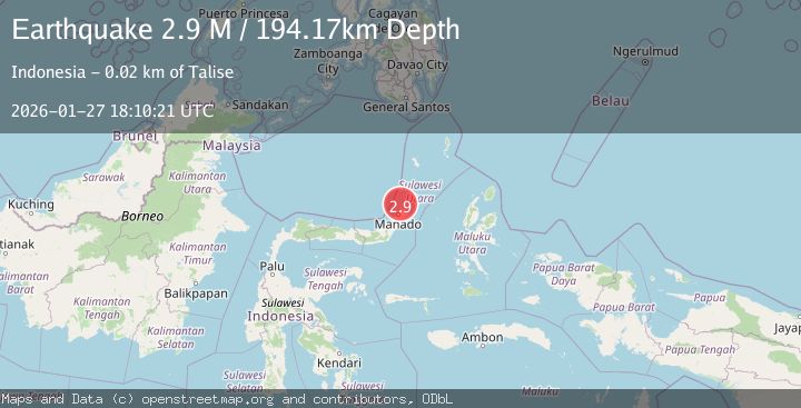
A 2.9 magnitude earthquake struck on Minahassa Peninsula, Sulawesi, at Tue, 27 Jan 2026 18:10:21 GMT. Depth: 194.170105km. Reviewed by BMKG seismologists, this minor quake occurred at a magnitude type of M.
Magnitude
2.9
M
Source
BMKG
Intensity
-
Agency Reports
1 Sources| Source | Magnitude | Depth | Time |
|---|---|---|---|
| BMKGPrimary | 2.9 | 194 km | 2 hours ago |
Earthquake Details
AutomaticEvent IDbmg2026bwxb
Tsunami PotentialNo
Magnitude TypeM
Nearest Places
- Tonggene Pintukota13.7 km
- Airbanua14.1 km
- Desa Airbanua14.5 km
- Wawunian14.5 km
- Tengkuhe Markonis14.6 km
Comments
Join the discussion about this event.
Latest Earthquakes
3.9Mag
ECUADOR
Time2 hours ago
Depth211.00 km
SourceQUI (Automatic)
4.6Mag
IONIAN SEA
Time2 hours ago
Depth9.70 km
SourceNOA (Automatic)
2.7Mag
DODECANESE ISLANDS, GREECE
Time2 hours ago
Depth8.00 km
SourceTHE (Automatic)
1.7Mag
24 km W of Mentone, Texas
Time2 hours ago
Depth0.00 km
SourceUSGS (Automatic)
3.0Mag
WESTERN TEXAS
Time2 hours ago
Depth9.70 km
SourceTX (Automatic)
Nearby Earthquakes
3.9Mag
CELEBES SEA
Time4 hours ago
Depth10.00 km
SourceBMKG (Automatic)
3.4Mag
Northern Molucca Sea
Time5 days ago
Depth11.41 km
SourceBMKG (Automatic)
3.0Mag
Talaud Islands, Indonesia
Time1 day ago
Depth117.70 km
SourceBMKG (Automatic)
3.1Mag
Northern Molucca Sea
Time9 hours ago
Depth31.63 km
SourceBMKG (Automatic)
3.6Mag
Celebes Sea
Time1 day ago
Depth84.83 km
SourceBMKG (Automatic)