Earthquake Timor Region
Sat, 31 Jan 2026 08:18:45 GMT
Time1 hour ago
Location
-9.1399, 124.0535
Depth
21.5 KM
Event Summary
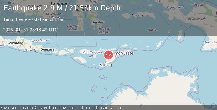
A 2.9 magnitude earthquake struck on Timor Region, at Sat, 31 Jan 2026 08:18:45 GMT. Depth: 21.527149km. Reviewed by BMKG seismologists, this minor quake occurred at a magnitude type of M.
Magnitude
2.9
M
Source
BMKG
Intensity
-
Agency Reports
1 Sources| Source | Magnitude | Depth | Time |
|---|---|---|---|
| BMKGPrimary | 2.9 | 22 km | 1 hour ago |
Earthquake Details
AutomaticEvent IDbmg2026cdlo
Tsunami PotentialNo
Magnitude TypeM
Nearest Places
- Pulau Batek16.1 km
- Point Panamtasa19.1 km
- River Oenis19.3 km
- River Niutmieo19.6 km
- Point Uthautfoo19.6 km
Comments
Join the discussion about this event.
Latest Earthquakes
1.3Mag
NORTHERN ITALY
Time1 hour ago
Depth2.70 km
SourceETHZ (Automatic)
1.7Mag
61 km NW of Skwentna, Alaska
Time1 hour ago
Depth0.50 km
SourceUSGS (Automatic)
1.8Mag
34 km SSE of Volcano, Hawaii
Time2 hours ago
Depth37.73 km
SourceUSGS (Automatic)
2.5Mag
Sumbawa Region, Indonesia
Time2 hours ago
Depth108.99 km
SourceBMKG (Automatic)
0.9Mag
81 km NNW of Karluk, Alaska
Time2 hours ago
Depth5.00 km
SourceUSGS (Automatic)
Nearby Earthquakes
4.7Mag
Timor Region
Time4 days ago
Depth90.63 km
SourceBMKG (Automatic)
2.5Mag
Timor Region
Time13 hours ago
Depth53.10 km
SourceBMKG (Automatic)
2.5Mag
Flores Region, Indonesia
Time1 week ago
Depth51.05 km
SourceBMKG (Automatic)
3.3Mag
Timor Region
Time5 days ago
Depth47.49 km
SourceBMKG (Automatic)
3.2Mag
Flores Region, Indonesia
Time1 week ago
Depth82.44 km
SourceBMKG (Automatic)